I cannot believe that all the effects which we now see were accomplished by the ordinary atmospheric influences at present in operation in this region, although the air, rain, and snow may have done much to give the monuments their present forms. The greater portion of the erosion must date back into the past, at least to the Post-Pliocene period. It is very probable that water had much to do with the formation of these monuments at the time when there was a far greater supply here than there is at this period.
Annual Report for 1873 (Hayden 1874, 32–33)
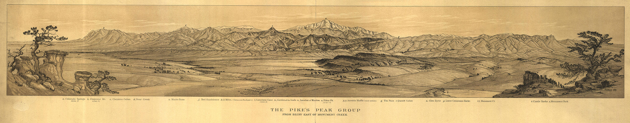
Panoramic View in Colorado Springs/The Pikes Peak Group
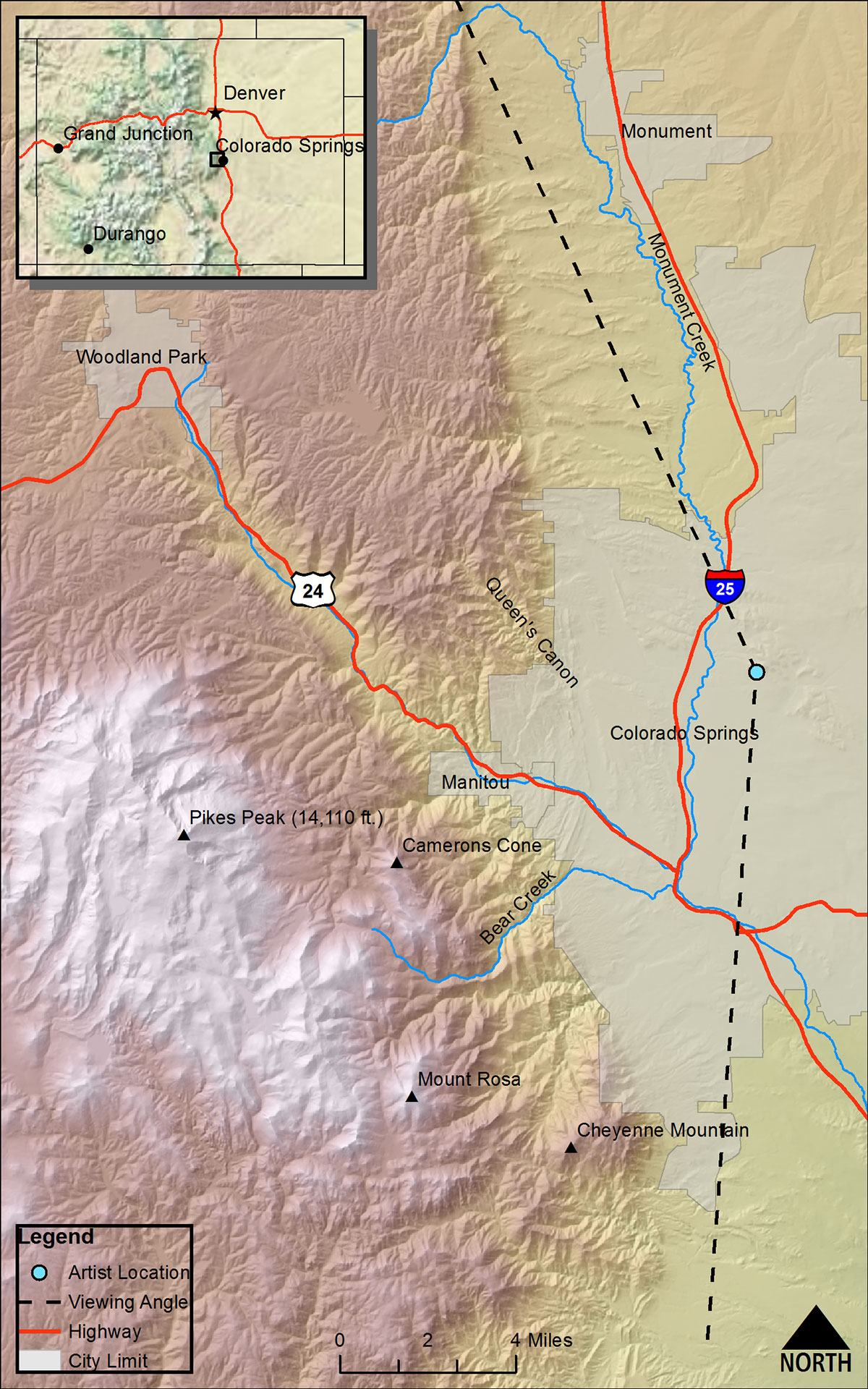
(Atlas [Hayden Survey 1877], Sheet XIX)DRAWN/TAKEN FROM GEOGRAPHIC COORDINATES: LATITUDE: 38°54′43′′ N | LONGITUDE: 104°48′35′′ W | UTM ZONE 13N | 516,619 mE | 4,306,786 mN
VIEW ANGLE: South clockwise through northwest | COUNTY: El Paso | NEAREST CITY: Colorado Springs
The exact point from which this drawing was done is from Pulpit Rock just on the northern edge of the campus of the University of Colorado, Colorado Springs. The sight lines are unimpeded by any of the other high terrain in the vicinity.
This panoramic view of “The Pikes Peak Group” may arguably be the most beautiful of the landscape sketches done by Holmes for the Hayden Survey. The perch that Holmes used was Pulpit Rock, which now sits just north of the University of Colorado, Colorado Springs campus. The framing of the drawing by sandstone hoodoos and gnarly Ponderosa pines may be an enhancement of what was really there, but the sketch is pure poetry on paper nonetheless. Aside from the poetic license he might have used, the rendering of the Pikes Peak region is a stunning and articulate artistic rendition.
There might be some argument about which landscape rendering in the survey publications is the most beautiful, but there is no question that this panorama of Pikes Peak and Colorado Springs is the most changed from Hayden’s time. When General William Jackson Palmer came to the area in 1869, there was little permanent human influence on the land. Only the area of Old Colorado City along Fountain Creek going up Ute Pass had any development to speak of.
Palmer came to this area scouting a route for his Denver & Rio Grande Western Railroad that was to connect Denver with points south and into the mountains. Palmer immediately fell in love with this place and started buying up land at a feverish pace. By 1871 he had established the resort community of Colorado Springs [(a) on the panorama]. Two interesting fabrications about this scene come from Palmer and Holmes.
First, there are no springs in Colorado Springs. The only springs in the area are the mineral springs in Manitou Springs (n) a few miles up Ute Pass from Palmer’s resort. Palmer thought that the word “springs” added some class to the name reminiscent of Saratoga Springs on the southern edge of the Adirondack Mountains in New York—a world-renowned resort at the time.
The second untruth, or at least omission, is that the Denver & Rio Grande Railroad was in place along the valley of Monument Creek by 1871, at least three years before Holmes drew this landscape. Holmes ignores this linear landscape artifact of human development in his drawing. Even though most of the land in the entire valley was already owned by Palmer and his friends, a railroad stretched across the entire scene, and people had been settled here for many years, Holmes depicts a natural environment rivaling his totally natural panoramas of places such as the San Juan Mountains, the La Plata Mountains, the Central Elk Mountains, and other pristine high-mountain scenes in Colorado.
Colorado Springs grew relatively slowly in the first few decades of its existence. Palmer built a steel mill in Pueblo to make the rails for his railroad system. Pueblo, located about forty miles south of Colorado Springs, was the fast-growing, industrial and urban center of southern Colorado for many years—far eclipsing the population growth of Colorado Springs. However, Palmer was not totally interested in rapid growth for the Springs, but rather creating a genteel, “dry,” resort town catering to the socially elite and existing without the usual urban problems.
The city grew in fits and starts through several phases. The first real growth spurt came from the discovery of gold in Cripple Creek in 1891. The Cripple Creek Mining District sits hidden behind the peak in this view. Most of the gold of Cripple Creek was not like that in California or Alaska, where almost anyone could pan for placer gold and make money if he or she were lucky enough. The gold of Cripple Creek was combined with other minerals in a telluride, a type of ore that called for a lot of capital and industrial might to extract the pure gold from the rock. The mines of Cripple Creek were all owned by people who had access to investors and could develop the mining and processing at an industrial scale. Most of the miners were merely hourly wage earners and lived in Cripple Creek, Victor, or some of the district’s other small towns. Most of the owners, bankers, investors, and so on lived in Colorado Springs—a much more attractive and comfortable setting. Large mansions lined the streets north of downtown Colorado Springs especially, along Nevada, Cascade, and Wood Avenues. The “Old North End” of the city is still a prized neighborhood.
Interestingly, in the mid- to late nineteenth century, Pikes Peak was the dominant icon when people around the country thought of Colorado. In fact, it became the basis for the gold rush that came to Colorado starting in 1859—often called the “Pikes Peak or Bust” gold rush. Unfortunately, Pikes Peak had nothing to do with that event. The rush itself started along Cherry Creek in Auraria (now near downtown Denver) and soon moved into the mountains, where Black Hawk and Central City gold camps boomed. Both of these mining camps were active and vibrant long before Hayden ever stepped foot into Colorado.
The second growth stimulus came in the early decades of the twentieth century. Consumption—tuberculosis, or TB—was one of the most widespread and contagious diseases of this time. No known cure existed. One proposed cure for TB was lots of sunshine and fresh air, two things the city had in abundance. It was also a disease of all classes including the rich and socially connected. Because Colorado Springs was a high-society resort town, many of these upper-echelon people visited the city. The logical outcome was for many of these rich (and some not so rich) TB patients to come to the region for the “cure.” Sanitaria for TB patients started to be built all over the area, and even individual families would build Gardiner tents for the less affluent to live in while they took the cure. These tents were really small, octagonal huts named for the early twentieth-century physician who designed them. Some of these “tents” can still be seen in the backyards of a few of the homes just north of downtown Colorado Springs. The Cragmor Sanatorium (where the University of Colorado, Colorado Springs campus now sits) was one of the more exclusive TB asylums with lavishly furnished, individual rooms, hospital facilities, and social functions the norm. Once antibiotics were discovered in 1928 and began to be available in 1939, the need for the sanitaria diminished rapidly. But many of the patients remained in the Springs and became the economic, intellectual, artistic, and social leaders of the community.
After a serious economic downturn for the city in the 1930s, World War II provided the next welcome growth surge for Colorado Springs. Politicians, the Chamber of Commerce, bankers, and others lobbied hard to get a share of the money going into the war. These efforts landed Camp Carson and Peterson Air Field. Thousands of military personnel and their support population came to the region. These were the harbingers of a military relationship with Colorado Springs that still is strong today with the US Air Force Academy, Fort Carson, North American Aerospace Defense Command (NORAD), Space Command, and the workforce that supports them.
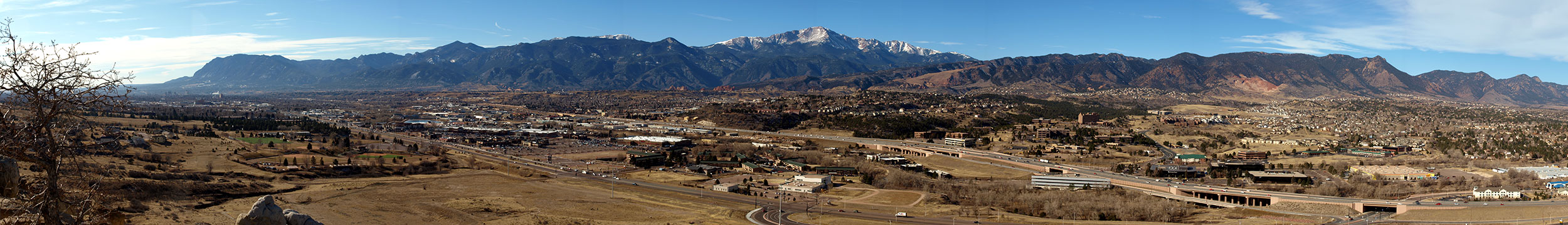
When Holmes drew his panorama, he probably could not have envisioned that the entire basin below him would eventually be filled with a substantial city. Even more incredible to him would have been the knowledge that only about a third of the city fills this scene today. The majority of land and population in Colorado Springs now spreads east and north of the Austin Bluffs where Holmes sat as he drew. This urban sprawl is fairly typical of US western cities, where land is perceived as cheap and everyone wants their own American dream of a place of their own. Colorado Springs is not yet a Houston or Phoenix, but it is now the second-largest city in Colorado, just behind Denver, and any future growth will be even farther into the eastern plains.
Most of the actual space of the drawing is the foreground that by its muted topography emphasizes the mountain backdrop. This broad valley is drained by innumerable small, intermittent creeks, Monument Creek (t, t) which enters the scene from the north (right), and Fountain Creek which flows down Ute Pass (q) and is confluent with Monument Creek. The only perennial water in the valley is in Fountain and Monument Creeks, and these are fed by precipitation that falls at the higher elevations in the mountains. The foreground valley is, in reality, quite dry. Yearly precipitation is less than sixteen inches on average in this landscape. For most purposes, only short-grass prairie can naturally thrive in this sere environment. Trees and shrubs, scarce in the drawing and in reality, are only viable when the land rises and orographic precipitation increases. It is a testament to human ingenuity, deep financial pockets, and dogged persistence that the city of Colorado Springs could become a major metropolitan area.
Growth of such a large community in this semiarid environment generates a need for water. As discussed above, water demand cannot begin to be satisfied locally. Colorado has water laws unlike those of the eastern United States. In the East water rights are called riparian rights—anyone on a stream, river, or lake can take water as they need it. This is a simple system, although even in the wet climes of the East, the dramatic increases in water demand are causing some serious rethinking of these laws. But from the beginning of settlement in the early 1850s, Colorado’s water laws were much more complex. Water was and is treated like any other commodity, with owners who can buy or sell the water based solely on economics, not location. The system here is called the law of prior appropriation, or the “Colorado Doctrine.”
In simple terms, this doctrine means that the first one to use water from some water source, whether or not the individual is near the source, gets the water. It can be moved in pipes or canals or ditches; it only has to be used for some beneficial purpose. As long as the owner keeps using the water for beneficial use, she or he owns the water. Owners can sell their rights to others or buy more rights from someone else. A significant characteristic of the law of prior appropriation, however, is that each right has a priority attached to it based on the first use of that water. Here in a dry climate, we do not have all the water everyone wants or needs. In a drought year, for example, if you have a young right, you may not get your water.
One might well ask, Where does this large and thirsty city of Colorado Springs get its water? The answer is long and complicated because so much water is needed for this community of nearly 500,000 people. The city does get a small amount of water from the slopes of Pikes Peak—these are some of the very first rights the city acquired. But most of the water comes from afar. The system of water sources and infrastructure to get the water here is complex and expensive. Colorado Springs gets water from places such as Twin Lakes, Turquoise Lake, and the Arkansas River near Leadville. It also gets a lot of water from the Western Slope near Mount Holy Cross and the Homestake Basin. And many of the large cities along the Front Range including Colorado Springs are buying up water rights along the lower Arkansas River east of Pueblo from farmers who have owned these rights for many years. Water is very valuable and it goes to the highest bidder—the big cities have the money to get the water, which leaves others scratching for answers to serious economic woes.
Pikes Peak is the obvious focus of this drawing by William Henry Holmes. The mountain is centered in the picture and symmetrically framed by all the other landforms Holmes included in his rendering. Pikes Peak is what geologists call a batholith—a very large pluton of igneous rock intruded from deep within the earth into already-existing country rock above. The Pikes Peak batholith is a particularly large batholith—one of the largest in North America. It is approximately forty miles in diameter and tens of thousands of feet thick. The rock one sees at the summit of the mountain was initially emplaced at least 20,000 feet below the surface. It is visible now only because it has been uplifted through a series of dramatic mountain-building episodes (called orogenies) during the last 1.1 billion years.
The lower mountains to either side of the peak, especially the Rampart Range to the north (right) look uniformly high. Many earth scientists see this consistent elevation as an indicator that these mountain tops were once planed down to sea level by eons of erosion. They were then subject to renewed uplift to form this peneplain surface. For the last 100 years or more, this Rampart Range peneplain has been the prototypical example of a peneplain used in geology lectures worldwide.
Although this panorama is one of only seven panoramic masterpieces in the Atlas, undoubtedly the most famous of all his publications, the amount of effort Hayden spent in describing the Pikes Peak region is minuscule. Such an absence is especially curious because, this scene, more than almost any other place in Colorado, likely encompasses a geologic continuum of a billion-plus years. Pikes Peak itself and much of the core of the other mountains in the area (e.g., Rampart Range) are composed almost exclusively of the billion-plus-year-old Pikes Peak granite pluton. Generally, whereas Hayden and his survey paid relatively scant attention to intrusive igneous rocks and many of the metamorphics of the territory/state, they spent huge amounts of time and energy analyzing and describing the myriad sedimentary rocks.
One reason for this bias could be that in 1870s there was no way to date igneous or metamorphic rocks with any accuracy. There were a few techniques such as analyzing crosscutting relationships, but these techniques only work in a few cases. Sedimentary rocks, on the other hand, were datable in a relative sense because of the occurrence of fossils that could be correlated with other sedimentary rock fossils to determine if a rock was older, younger, or about the same age. This relative dating using fossils was a mainstay of geology almost from its beginnings in England in the late eighteenth and early nineteenth centuries.
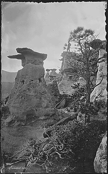 Monument Park, El Paso, County, Colorado 1874
(photo by William Henry Jackson, ca. 1901, courtesy of the US National Archives)
Luckily, in addition to the massive Pikes Peak pluton, a huge collection of sedimentary rocks lies just east of the mountains and on into the plains. A few of these include the red beds of the Fountain formation (Pennsylvanian to Permian ≈ 290 mya) and the Lyons formation (upper Permian ≈ 250 mya). There is a small exposed deposit of the famous Morrison formation (Jurassic ≈ 150 mya—see section 5, on Morrison) and the ubiquitous Dakota sandstone (lower Cretaceous ≈ 140 mya) derived from massive beach deposits found throughout Colorado and much of the West. The entire low-lying basin that makes up most of the scene is almost totally underlain by Pierre shale (Cretaceous ≈ 70 mya). Also in the scene are the Laramie formation (containing most of the coal beds of the region), the Fox Hills formation, quaternary gravels, and recent alluvial deposits. This list is not exhaustive, but it gives one a good feel for the extent of time that can be interpreted from this locale. Yet Hayden makes little of it—curious.
Finally, one of the explicitly stated purposes of the Hayden Survey was to find economically significant resources, especially minerals that could be exploited during the rapid development of the territory/state of Colorado. In this scene there is only one visible resource that has been extracted. On the photo you can see two “scars” on the mountain sides just to the right of center. These scars are from the quarrying of limestone, mostly from the Manitou limestone formation, for use as aggregate. One other resource is not readily visible but comes from the Laramie formation mentioned above that contains large deposits of coal. Coal measures, Hayden’s term, have been mined from areas near the far right of the scene, under Austin Bluffs, where the University sits, and nearly to Peterson Field airport. This coal was mined from the early twentieth century to about 1965 in deep underground mines that no longer are active.
Many present-day geologists and paleontologists look at this area as a cornucopia of valuable and visible earth history and the geologic development of Colorado and the West. This striking scene could be a testament to that thinking, and scientists from many other places bring students to the region annually to study this open book of geology and natural history. Although Hayden’s Survey contains minimal discussion of the area, the area has become a Mecca for budding scholars from around the country.