We will now ascend the valley of Lake Creek, and wend our way over the great Sawatch range. The valley of Lake Creek is filled with the morainal deposits for which this range is so remarkable . . . The two lakes are about 350 yards apart, with a small stream, perhaps 20 feet wide, flowing from one to the other. The interval is made up of worn detrital matter, but over it and around both lakes are mounds or oblong ridges of drift.
Annual Report for 1873 (Hayden 1874, 53)
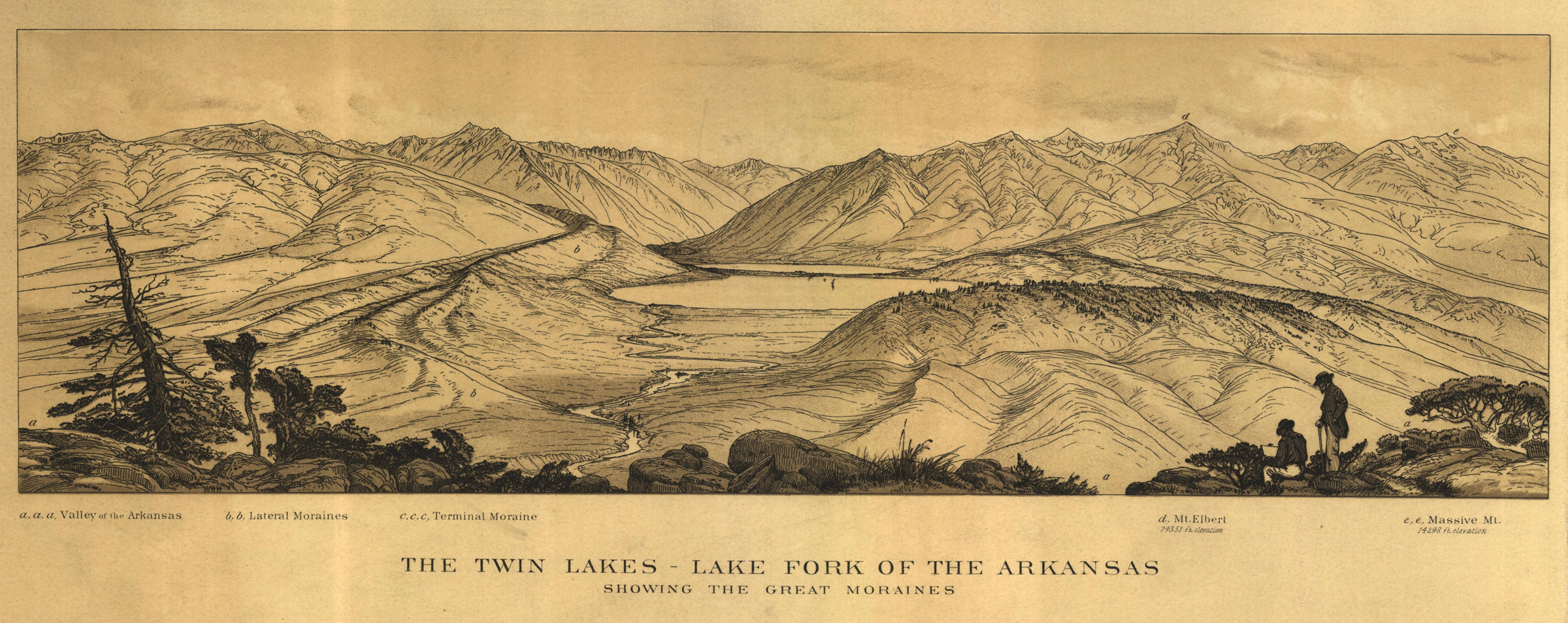
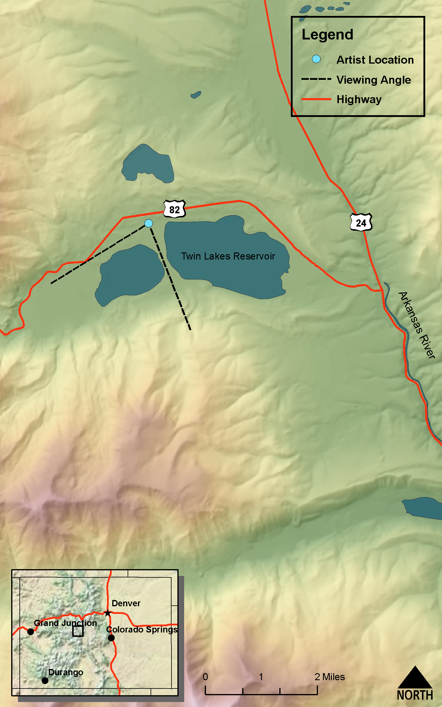
The Twin Lakes-Lake Fork of the Arkansas
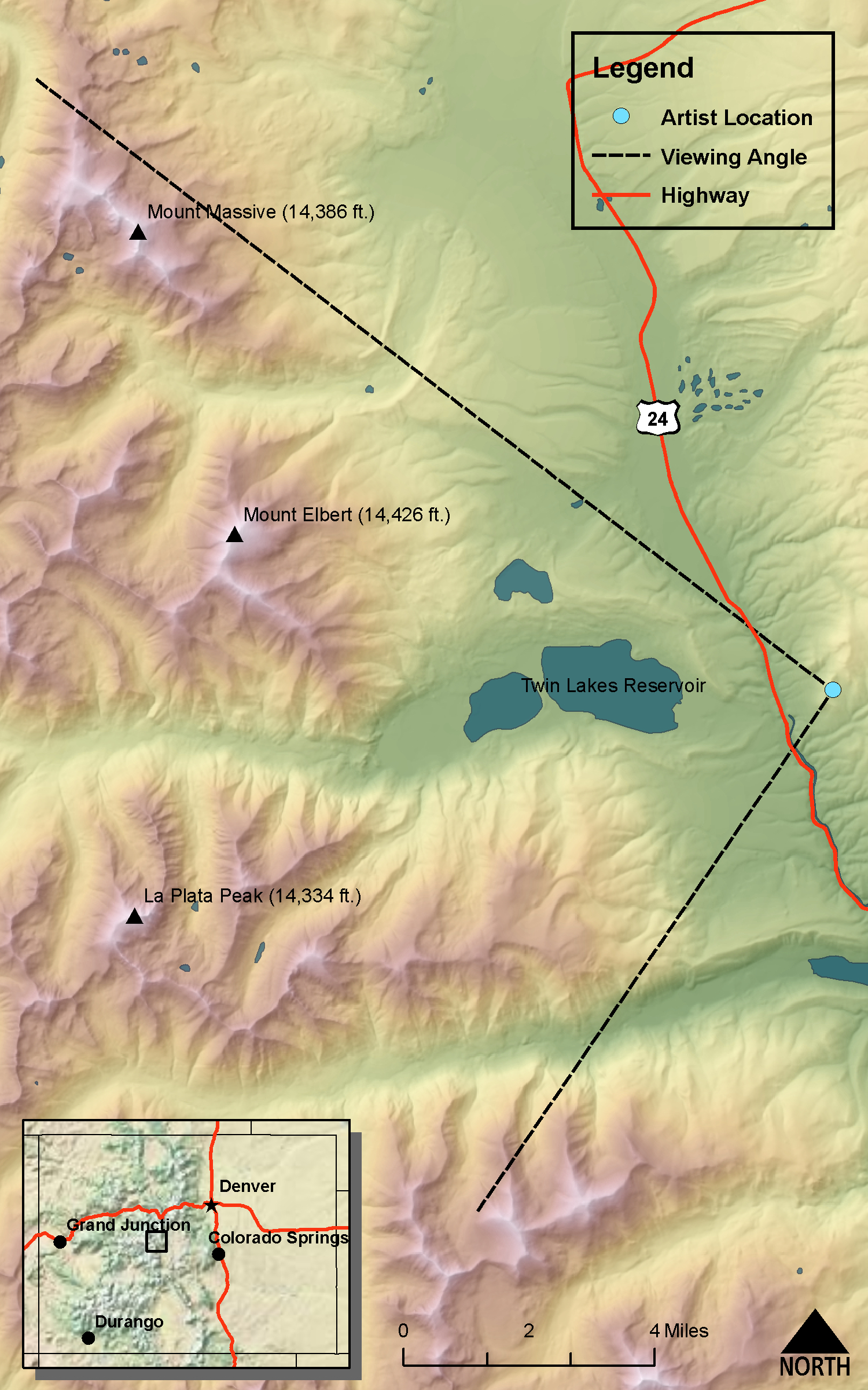
DRAWN/TAKEN FROM GEOGRAPHIC COORDINATES: LATITUDE: 39°05′10′′ N | LONGITUDE: 106°16′03′′ W | UTM zone 13N | 390,364 mE | 4,326,850 mN
VIEW ANGLE: Southwest clockwise through northwest | COUNTY: Lake | NEAREST CITY: Leadville
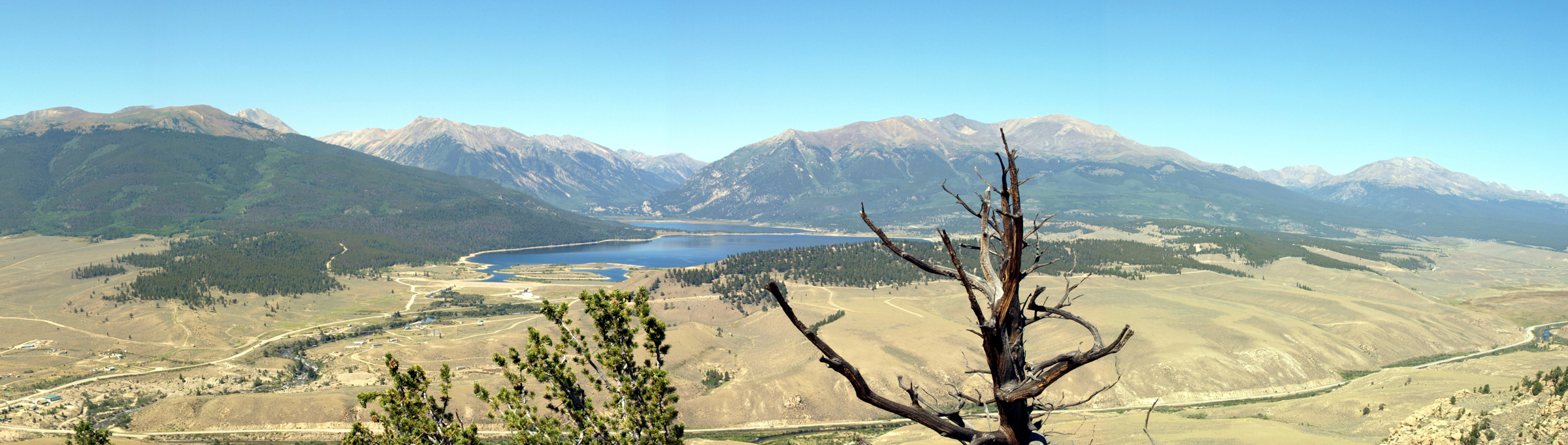
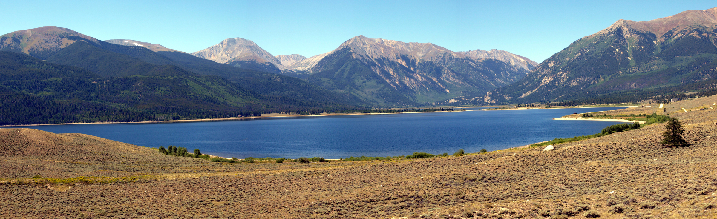
The photo and drawing were taken from the hillside across the Arkansas River from the Twin Lakes Reservoir. The two lakes sit in a broad, flat-bottomed valley shaped by extensive glaciers.

Upper Twin Lake, Colorado
(Annual Report for 1873 Field Season Hayden 1874 -, Figure 10, page 50)DRAWN/TAKEN FROM GEOGRAPHIC COORDINATES: LATITUDE: 39°05′40′′ N | LONGITUDE: 106°21′31′′ W | UTM zone 13N | 382,461 mE | 4,327,922 mN
VIEW ANGLE: West-southwest | COUNTY: Lake | NEAREST CITY: Leadville
The campsite in this sketch is along the northeastern shore of Upper Twin Lake. Although the water level is higher now because of the dam, this stretch of sandy ground can still be seen—albeit without the trees.
The Twin Lakes and their valley are one of the most recognizable waterscapes in Colorado. This distinctive synthesis of water and land could be considered the quintessential melding of mountains, flowing water, and ancient glaciers. Hayden’s surveyors certainly recognized the area’s glacial heredity. The quote above describes mounds and ridges of drift—what we today call morainal till. Glaciers once filled this flat-bottomed valley and deposited huge amounts of rock detritus onto the valley floor during their retreats. Evidence exists on the land today of at least two major glacial advances and subsequent retreats. These two glacial episodes are regionally called the Bull Lake and the Pinedale after their type locations in the Wind River Mountains of Wyoming. There are no ironclad dates acknowledged for these events, but the general consensus is that the Bull Lake advance started about 160,000 years ago and lasted for approximately 40,000 years with minor fluctuations in the glacial extent over that time period. The Pinedale glaciation is newer and the general dates go from about 110,000 years ago to between 12,000 and 10,000 years ago dependent upon elevation and aspect. These two most recent major glacial advances obliterated nearly all evidence of the several, older glacial episodes that most assuredly also occurred here.
Glacial recessional moraines naturally dammed the lower (eastern) lake (b and c on the panorama. There was also a dam created by the latest glaciation that created the isthmus between the two lakes. The area just west of the lakes was recognized even in Hayden’s time as a bog that has been steadily invading the upper lake for centuries. That bog is still advancing today as evidenced by the massive willow stands and other water-loving vegetation. When the vegetation dies, the plant debris collects decade after decade, filling the shallows of the lake, and finally decomposes to peat and soil. This natural process, if left alone, in theory will eventually eliminate the lakes and make the valley bottom a flat, soggy marshland.
A geologic map of the surrounding mountains could easily remind someone of an abstract pattern on a quilt or even a Jackson Pollock painting. The mountains that loom over the valley are a hodgepodge of igneous granites and metamorphic gneisses and schists from three widely separated geologic times. There are ancient rocks that date from approximately 1.7 billion years ago—some of the oldest rock in the state—and rocks that date from 1.2 billion years ago. The geology just west of the lakes was emplaced a mere 65 millions years before today. All of these formations have been highly modified by erosion and glaciation. As discussed in the previous section, 10, on the Sawatch Range, this elongated mountain system is the core of a gigantic arched anticline that defines the entire central mountain section of Colorado. As the highest topography of that old anticline, Mt. Elbert (c) on the north side of the valley is the dominating mountain presence in the area. At 14,433 feet, it is the highest mountain in Colorado and second only to Mt. Whitney (14,505 feet) in California as the tallest mountain in the lower-forty-eight United States.
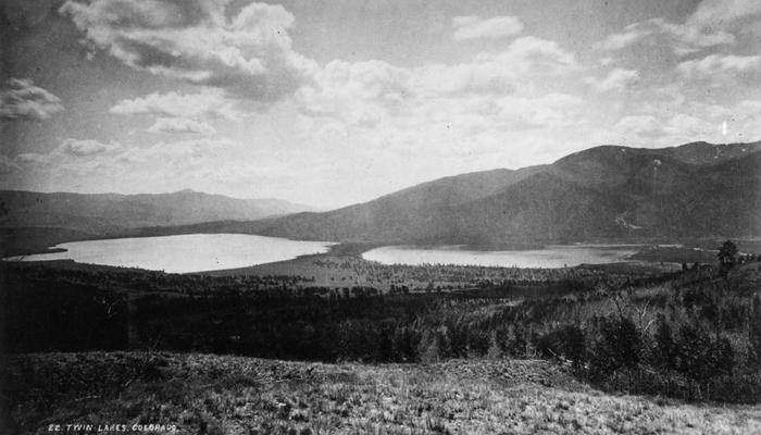 The Twin Lakes
(photo by William Henry Jackson, courtesy of the US Geological Survey Denver Library) A distant view, as seen from an elevation of 800 feet above them, on one of the spurs of Mt. Elbert, Lake County, Colorado, 1873.
The North and South Forks of Lake Creek merge about seven miles upstream from the western shore of the lakes to become the Lake Creek, which flows into the upper lake. Lake Creek and its North Fork have become the natural passageway up to the Continental Divide and the pass to the West Slope of Colorado. The pass it crosses was called Lake Creek Pass by Hayden and Hunter’s Pass by the locals until its name was permanently changed to Independence Pass (12,093 feet)—one of the highest paved-road passes in the state. The top of the pass is an enigmatically flat area consisting of small marshy areas and numerous ponds. A visitor rest area has been built here with a walkway out onto the alpine tundra that exists at this elevation. The western side of the pass leads down to Aspen, the old gold- and silver-mining camp that has become the definition of a mountain playground for the rich and famous.
Independence Pass was critical to the development of the Roaring Fork Valley because it was the only route in for supplies and route out for ore from the mines around Aspen. The deep, shear walls of the Colorado River through Glenwood Canyon made it virtually impossible to come into the valley from the north. Only after the railroads, especially the Colorado Midland, were built from the east to Glenwood Springs was access easily available from down valley. Once the railroads arrived, the pass and the toll road that was built over it were nearly abandoned and went into deep disrepair.
In 1972 the city of Colorado Springs completed a huge expansion project that would help supply large volumes of water to its growing urban area. In conjunction with several other cities and state and federal agencies, the city purchased a large number of shares in the Twin Lakes Company and became part of what has come to be called the Frying Pan–Arkansas (or Fry-Ark) Project. This massive operation combines Eastern Slope water from the Arkansas River Basin with Western Slope water from the Roaring Fork River and its tributary, the Frying Pan River. A large tunnel and a system of reservoirs and pumping stations on the western side of the Continental Divide move water under Independence Pass into Lake Creek and down to the Twin Lakes Reservoir, as it is now called. A dam extension has been built on top of the naturally created glacial moraine dam at the eastern edge of the lakes to augment the holding capacity of the reservoir. You can easily see this dam as you turn off of US Highway 24 onto Colorado Highway 82 heading west toward Independence Pass.
One of the unique aspects to the entire Fry-Ark project is the “pumped hydroelectric storage” system that has been built on the shores of lower Twin Lake. One of the main issues with many electric grids is that they must be built to satisfy the absolute peak-demand loads that occur during daytime or during hot weather, when air conditioning uses large amounts of electricity. For most of the time, the generators are functioning at far below their maximum capacity. A pumped hydroelectric storage system is designed to help even out the need for large electricity-generating capability built just for peak hours. A pumped storage facility is built specifically to generate energy during peak periods.
For the Twin Lakes project, the Fry-Ark operators have built a hydroelectric plant at the very northwestern shore of the lower lake. Some water is diverted from Turquoise Lake (just west of Leadville and upstream in the Arkansas River Basin from Twin Lakes). But most of the water used for the hydroelectric turbines comes from the Twin Lakes themselves. A small reservoir called the Mt. Elbert Forebay was built on the mesa just north and above the lakes. Water from this small reservoir is funneled down to the generating turbines at the Mt. Elbert Hydroelectric Plant during peak demand periods. During off-peak times, the generators are run in reverse using electricity from the grid and become pumps that move Twin Lakes water back uphill to the Forebay. During the next peak period, the water again runs down the conduit to the generators to produce electric power for the grid and is pumped back uphill after the peak is over. This electricity is not a “free lunch”’ but the advantage of the system is that high-rate peak electricity is generated and makes an electrical profit. During low-rate times of off-peak energy demand, lower-cost power is used to run the pumps and replenish the system. This is an intricate system that relies on rational use of electricity and the inevitable peaks and valleys of electricity demand.
Even with the augmentation of the dam and the construction of the hydroelectric plant, Hayden and crew would still recognize the panoramic view of today. The more intimate drawing of the campsite on the Upper Twin Lake would be less recognizable to them. The trees and shrubs are long gone, and the water level is much higher. The shores of the lakes are probably the most disturbed parts of the landscape, but the overall, large-scale view of the valley remains dramatic.