Along this well-defined line the occurrence of these rather simply composed and structured rocks abruptly ceases, and westward for many miles no sandstones, slates, or shales, or other comparatively little changed and normal sedimentary rocks are to be found. An entirely different class of rocks take their place. First rising either abruptly or in great massive slopes for one to two thousand feet from beneath the lowest of the Triassic sandstones they form the first great eastern slope of the main range. This slope is not an unbroken north and south line, for all the streams from the range beyond cut great cañon-gashes through it, emerging from which they break across the zone of upturned sedimentary ridges and thence out on to the plains.
Annual Report for 1873 (Hayden 1874, 138)
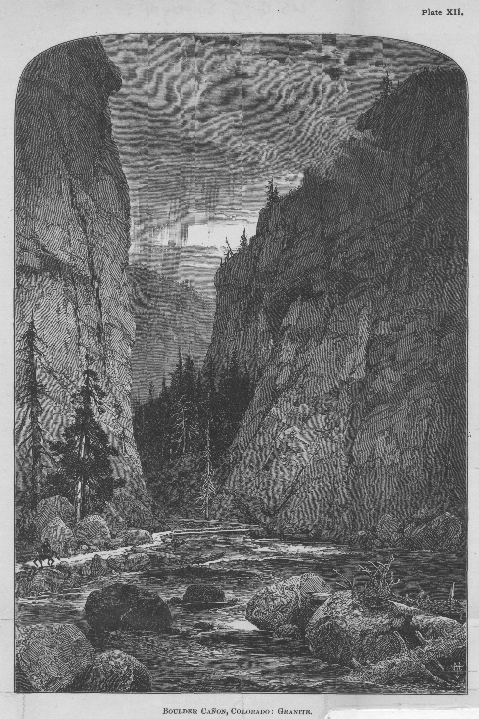
Boulder Cañon, Colorado: Granite
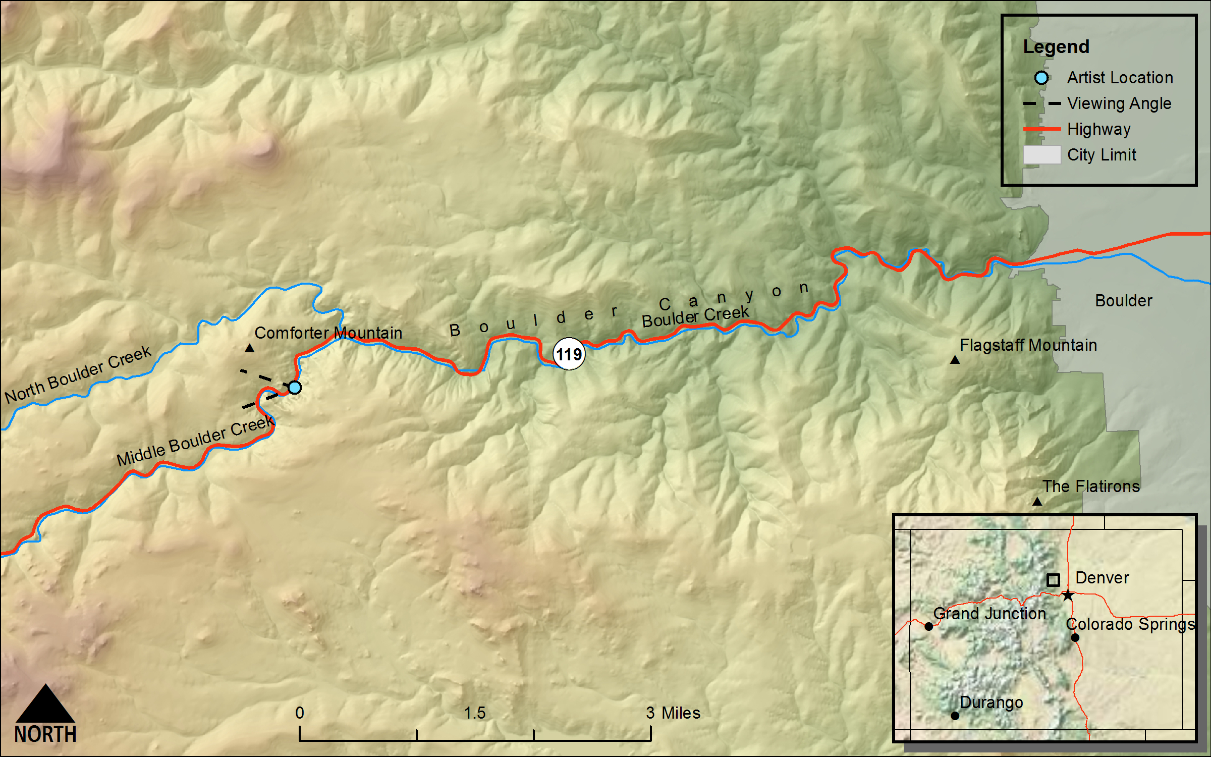
(Annual Report for the 1874 Field Season [Hayden 1876], Plate XII, page 50)DRAWN/TAKEN FROM GEOGRAPHIC COORDINATES: LATITUDE: 39°59′58′′ N | LONGITUDE: 105°24′51′′ W | UTM zone 13N | 464,695 mE | 4,427,325 mN
VIEW ANGLE: West | COUNTY: Boulder | NEAREST CITY: Boulder
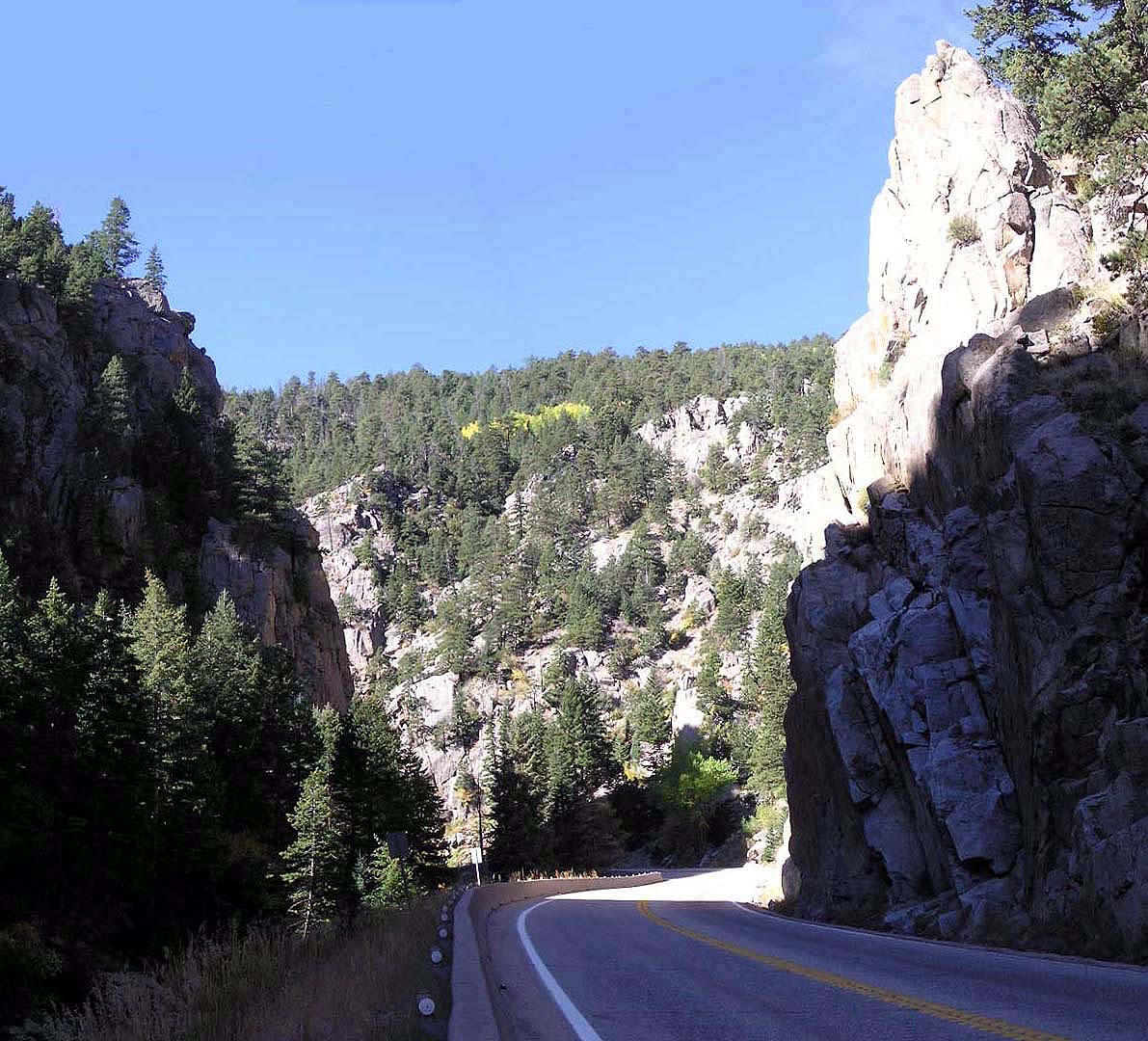
The narrowest part of Boulder Cañon makes this a very striking view. Thomas Moran, who drew this sketch, made it look even more dramatic—a practice he often used when dealing with landscapes of the West (see section 9, on Mt. Holy Cross). Comparing his drawing to the photo, you can see many changes that Moran made to the original landscape. The granite walls of the canyon serve as good, solid rock for the local climbing community.
Thomas Moran was a noted nineteenth-century landscape artist who gave many people in the United States their first (and maybe their only) views of magnificent western vistas. But Moran rarely met a dramatic natural scene that he did not want to “enhance” (also see the drawing of “Mount of the Holy Cross” in section 9). This is certainly the case with this dark and gothic-like pen-and-ink sketch of Boulder Cañon. The walls of the canyon at this juncture are very steep in real life, but they do not approach the near vertical depicted by Moran. But he was not one to apologize in the least for his artistic flourishes. In his book about Moran, Thurman Wilkins includes and interprets this Moran quote: “‘My purpose was to convey a true expression of the region,’ not its strict topography” (Wilkins 1998, 140).
Moran worked with Hayden very closely during the Hayden Survey of the Yellowstone region at the beginning of the 1870s. Moran’s world-famous painting “Grand Canyon of the Yellowstone” attests to his skill at landscape dramatization and aided the efforts at the time to make Yellowstone our first national park. After those Yellowstone days, Moran started working with John Wesley Powell in his surveys of the plateau country west and south of Colorado, and Hayden never officially used Moran in his multiyear survey of Colorado. But after Moran saw William Henry Jackson’s stunning photograph of Mount of the Holy Cross, he decided to head to Colorado in the summer of 1874 and became part of a “secondary expedition” loosely attached to the official Hayden work. He wanted to paint this elusive mountain and succeeded in getting the necessary sketches and the landscape vision burned into his brain that turned into his famous painting. Oddly, Hayden never mentions Moran’s Holy Cross work in the Annual Report for that year nor this sketch Moran did of Boulder Cañon.
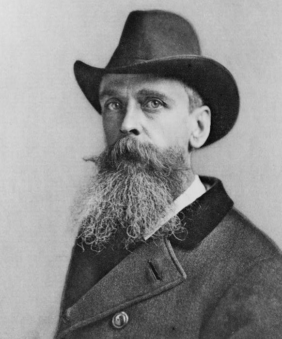 Photo of Thomas Moran
(courtesy of the Library of Congress) The famous artist who worked with Hayden for several years both in Colorado and the Yellowstone country, ca. 1890–96.
The production and fieldwork for the Annual Report for the field season highlight some interesting aspects of the relationship between Hayden and Moran and how Moran worked. A publication called Picturesque America had asked Moran to illustrate an article about the Rocky Mountains. As confirmed in a book by Joni Kinsey, Moran took many of Jackson’s photographs and drew the scenes without ever being there—this is the case for this sketch of Boulder Cañon (Kinsey 1992). Moran drew it without ever going to Boulder Cañon. There were several others sketches that Moran drew for Picturesque America that Hayden used throughout the Annual Report that were also drawn from photographs instead of in person. This particular sketch of Boulder Cañon is placed in the Annual Report in the middle of a discussion about glaciations along the Arkansas River—nowhere near Boulder Cañon. In fact there is no discussion whatsoever of Boulder Cañon in this report and few mentions of Boulder Creek in any of the Annual Reports for the entire survey. Nonetheless, it is a beautiful rendering of an important geologic area and has been included here for those reasons.
Although the sketch has narrowed and “verticalized” the canyon, the granite walls of this gorge are in reality still very steep in this section along Middle Boulder Creek. Most of this rock of the mountain area to the west of the city of Boulder consists of Boulder Creek granite: often called granodiorite because of its dark gray banding. This is a very ancient, Precambrian rock that has been dated using radioisotopes to be about 1.7 billion years old, making it some of the oldest intrusive igneous rock in Colorado. The massive batholith of granite is cut by innumerable fracture and fissure zones that have been injected with mineralized fluids over the eons. Because of these mineralized veins, this part of the southern Rocky Mountains west of Boulder is the farthest northeastern extent of the northeast-southwest-trending Colorado mineralized belt that stretches from this part of Boulder County to the Silverton area in San Juan County. Most valuable minerals, with a few exceptions, that have been mined in Colorado come from within this belt. This wide geologic swathe of mountainous terrain has produced much of the gold, silver, zinc, copper, lead, and other minerals that have played such an important role in Colorado history.
There was a small pulse of placer mining in Boulder Cañon during the same time as the rush and major gold strikes at Auraria and Central City that were erroneously known at the time as “Pikes Peak or Bust.” But these placer finds in Boulder County were small and never significant. The real boom in mineral mining in the county occurred from around 1900 to just after 1945—a quarter of a century after the Hayden Survey finished its work in Colorado. A mineral called ferberite was discovered in the uplands just to the north of the canyon of Middle Boulder Creek. Ferberite is a highly concentrated ore of tungsten. It was not until the late nineteenth century that tungsten was found to be an important metal. It was useful in hardening steel—this was considered nearly essential in producing effective ordnance such as artillery shells (a characteristic that became critical during World War I). Tungsten has one of the highest melting points of any metal (6,192°F / 3,422°C). Thomas Edison was credited with inventing the incandescent light bulb in 1879 and used a carbonized cotton thread for the filament in his first successful bulbs. When tungsten became economically available, Edison and his company General Electric realized that it was a much better and more durable alternative to the carbon fiber filaments. General Electric patented the use of tungsten in light bulbs in 1906.
The tungsten mining district in Boulder County was the most prolific producer in the United States for the first half of the twentieth century. The first claims were made based on miners just gathering the ferberite off of the ground where the mineral veins appeared at the surface. Deeper mines were eventually developed, but the shafts never reached more than a few hundred feet below ground. The district produced more than 50 percent of all tungsten produced in the United States during this period from a maximum of 225 producing mines. At the height of the tungsten era in Boulder County, the mining district stretched from Hurricane Hill just north of Nederland eastward to within four miles of the city of Boulder. The district was only about two miles wide at its western limit on Hurricane Hill and became much narrower as it moved east. The entire district went inactive shortly after World War II, although many of the veins probably extend to thousands of feet below the surface. The cost of tungsten recovery in these deep veins is prohibitive, and there would be significant resistance to extensive mining in the area today. Boulder Cañon and the land of the old mining district are now the site of a vigorous recreational industry and the location of many exurban housing developments that cater to the Boulder area.
By far the largest group of recreational users in Boulder Cañon is rock climbers. Sport and adventure climbing are popular in Boulder Cañon because of the great climbing rock here—that hard, granular granite that does not decompose easily in conjunction with the steep terrain. On any given nice day, no matter the season, there could well be hundreds of climbers of all skill levels using the dozens upon dozens of established sport-climbing routes and a multitude of adventure-climbing ones. Climbing is widespread here because there is a large contingent of outdoor enthusiasts just a few short miles down the canyon in Boulder, especially students who come to this University of Colorado campus and discover the climbing and other sports available in the area. Many come to the university here simply because of these opportunities.
This canyon scene is part of the home ground of a research endeavor that started a half century ago and has become essential for understanding this place. When Alexander von Humboldt lived and studied among the native peoples of the Andes in the nineteenth century, those peoples naturally categorized their mountainous lands according to elevation and temperature—e.g., tierra caliente, tierra fria (hot and cold land, respectively). Humboldt received credit for this obvious classification scheme because he wrote of it in his magnum opus Cosmos. Humboldt 1845-52 That the land and the living biota on it change with elevation and climate was an idea that would naturally be repeated along the vertically exaggerated Front Range of Colorado, albeit in a much more rigorous and scientific way.
In the 1950s and 1960s, John Marr was a professor of biology/ecology at the University of Colorado, Boulder. He knew the natural world in his backyard was an interesting and complex place and wanted to see how it worked and to what extent it could be more or less explained. Marr set out to gather data like any good field scientist and established a series of weather/climate stations strung along an east-west line from near Longmont up to the land above the trees near the Continental Divide in what is now known as the Indian Peaks and especially along the now scientifically famous Niwot Ridge. Along with the long-term climate data he collected, Marr and his students did intensive field studies of the plant communities along with other natural characteristics such as soils and landforms—or as we define it today, the ecosystems of the area.
One of the fruits of Marr’s work was a treatise on the “lifezones” that can be found from the eastern plains of Colorado to the alpine along the transect of climate stations he established (Marr 1961).The system he devised and repeatedly modified included the plains: below 6,000 feet; the foothills/lower montane: between 6,000 and 7,700 feet; the upper montane: from 8,000 to 9,000 feet; the subalpine: between 9,300 and 11,000 feet; and the alpine: above 11,400 feet. These are all flexible elevations that change with slope aspect and other factors. And between each of the major lifezones are transitional zones called ecotones where the lifezones interfinger and wax and wane. Within each zone there are several possible ecosystems. The term lifezone is now often viewed by ecologists as too restrictive and formulaic, but for most of us, these lifezones and the ecosystems within them are a good way to help us organize the complexities of mountain environments. Marr began the conversation, but now newer, more sophisticated methods of landscape analysis are used. Yet Marr’s legacy lives on and is still productively used by many today.
Even though Hayden never wrote about going up Boulder Cañon in his reports, the canyon was and still is an important place for geologists, rock climbers, and travelers. The canyon bottom is an important portal to the mountains from the eastern plains, and still has a visceral attraction to many who live and visit the Front Range.