Our trip down the Eagle River had for its principal objective the discovery of some way of access to the mountain of the Holy Cross. A little stream joins the Eagle River from the west side, which rises among the group of mountain-peaks of which the Holy Cross is most conspicuous . . .
The main mass of the peak, like the whole of the Sawatch range, is composed of granite gneiss. The summit of the Holy Cross is covered with fragments of banded gneiss.
Annual Report for 1873 (Hayden 1874, 73-74)
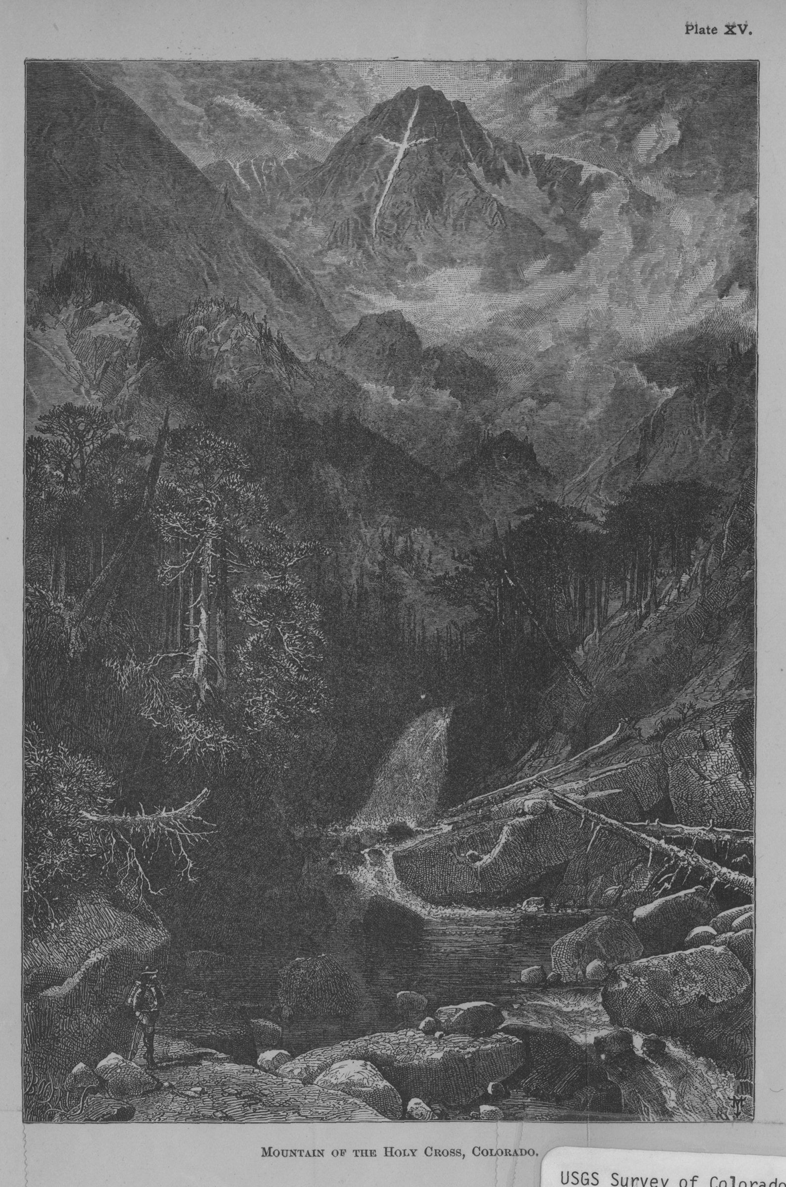

Mountain of the Holy Cross, Colorado
Annual Report for 1873 Field Season [Hayden 1874], Figure 18)DRAWN/TAKEN FROM GEOGRAPHIC COORDINATES: LATITUDE: 39°28′40′′ N | LONGITUDE: 106°27′35′′ W | UTM zone 13N | 374,413 mE | 4,370,650 mN
VIEW ANGLE: Southwest | COUNTY: Eagle | NEAREST CITY: Redcliff
The only close view of the east face of the Mount of the Holy Cross is from Notch Mountain (13,237 feet). This Thomas Moran drawing was essentially done from Notch, but he took considerable latitude in how the mountain would be illustrated. It is a beautiful rendering nonetheless.

Mount Holy Cross, at 14,005 feet, barely makes the list of fifty-four mountains in Colorado that top the 14,000-foot mark. Only Sunshine Peak (14,001 feet) is lower and still on the list. But after Pikes Peak (itself nowhere near the top of the list), Mount Holy Cross might be the most famous of the 14ers in the state. The legend of the existence of Mount Holy Cross preceded its “discovery” for decades. The earliest written account of Holy Cross comes from Samuel Bowles, who saw the famed cross from atop Grays Peak nearly forty miles to the east. The fame of the cross is most likely because of its obvious religious symbology to those who are moved by such signs. Bowles, in his 1869 book on Colorado stated it this way: “It is as if God has set His sign, His seal, His province there—a beacon upon the very center and height of the Continent to all its people and all its generations” (Bowles 1869, 96). Bowles could not place where the mountain was precisely located. There were many rumors and vague allusions to its location, but there was neither a map nor a set of firm coordinates.
The search for a closer look at Holy Cross was intense for the Hayden Survey. William Henry Jackson made it almost a personal pilgrimage to find and produce a close-up photograph of the cross during the summer 1873 field season. Jackson eventually found that the best and closest view of the cross was from the top of Notch Mountain, less than one and one-half miles to the northeast of Holy Cross. Jackson’s photo became world famous.
The next year Thomas Moran went to the area and sketched the mountain—this sketch is included in Hayden’s Annual Report for 1874 (Hayden 1874 ; Hayden 1876) and became the basis for Moran’s famous seven-by-five-foot painting of Mount Holy Cross. Moran’s artistic license shows the mountain in a setting that does not really exist as he painted it. As mentioned in the section 4, on Boulder Cañon, he was notorious for “enhancing” his paintings, and the dramatic effects he created seemed to be what people wanted from western art of that era. Because of Moran’s extensive alterations to reality, the photograph taken for the book does not (and could not) match the drawing with the precision that many of the photographs in the book align with the corresponding landscape renderings. Art historians call this rearranging of reality by artists “conflation.” A conflated image has all the salient elements of the real scene, but many details are changed to make the rendering more dramatic or pleasing according to the artist’s bent.
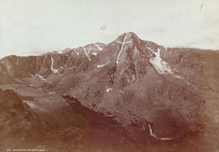 Mountain of the Holy Cross
(photo by William Henry Jackson, courtesy of the University of Chicago Library) This is the iconic first photograph of the famous, almost mythical, mountain, 1873.
Mount Holy Cross now sits in the middle of a federally designated wilderness area that carries its name. Congress designated the wilderness area, with its 122,884 acres, in 1980. One influence that helped promote the wilderness designation was a compromise among the local residents, the White River and Pike-San Isabel National Forests, and the cities of Colorado Springs and Aurora. This compromise in the Colorado Wilderness Act of 1980 created the wilderness area but stated that nothing in the act should be construed to mean that neither Colorado Springs nor Aurora would lose water rights from the area that the cities already had procured. See section 1, on Pikes Peak/Colorado Springs, for a discussion of the law of “prior appropriation.”
The two cities had acquired significant water rights in the area prior to 1980, and they were pushing to develop those rights more fully. The modified wilderness designation kept the area somewhat protected environmentally while allowing more limited development of the water rights in the Homestake Water Development Project. Today water is taken from this Western Slope land through the 5.2-mile-long Homestake Tunnel and put into Turquoise Lake on the Eastern Slope. Water then moves to the two cities using existing waterways (e.g., the Arkansas River), pipelines, and other storage facilities (e.g., Twin Lakes). This issue is still smoldering in the background with a proposed Homestake II project, which is at present quiescent. Colorado Springs and Aurora will surely try to move forward with expanded water development in the future. They have already proposed a “Plan B” for Homestake II.
The quote from Samuel Bowles near the start of this section about the religious significance of Mount Holy Cross is wrong in at least one respect. He states that the cross is there for “all . . . generations” (Bowles 1869, 96). As you can clearly see from the photograph taken in July 2003, the cross of Mount Holy Cross is only a shadow of its former self.
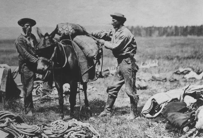 William Henry Jackson packing a mule
 (photo by William Henry Jackson, courtesy of the National Park Service) This is a self-portrait of William H. Jackson packing his mule, 1871.
If you look at the peak closely you are able to see the vertical cleft. But the nearly horizontal arms to either side are almost imperceptible because all of the “permanent” snow that made the cross had melted during the summer drought of 2003, when the photo was taken. The irony in this is obvious. Many people have taken the cross as a direct religious sign, an inspiring and a sacred signal that the natural world acknowledges us humans. The seemingly enduring snow was gone during this drought year because, in large part, of what we as humans have been and are doing to the natural environment. The horizontal arms of the cross have since recovered their “permanent” snow patch. The years-long drought was over, and more snow was falling each winter. But the facts remain: global warming is a reality (whether you insist it is a natural cycle or human caused).
The arms of Mount Holy Cross are just a small marker that indicates where our planet may be headed. Those who are religious might take heart that the cross is trying to tell us something. Those who are scientific can comprehend the significance of this, so far, temporary loss. Neither of these groups is necessarily exclusive, and all people interested in where our planet is headed need to be aware of even these small signs along the way. The pursuit of this icon by Jackson, Moran, and others shows the strong pull of myth, hope, and religious fervor. We will see in the coming decades if this landscape beacon will survive or become a lost symbol.