. . . there is a series of maroon or deep purplish-brown sandstones, quartzites, and conglomerates. These vary much in color, from a light brick-red to a purplish-brown or maroon color. They reach a thickness of at least 1,500 feet, and probably more. . . . It may be found capping the highest peaks of Elk Mountains, over 14,000 feet above sea-level, and is weathered into unique forms of cones, pyramids, &c.
Annual Report for the 1873 Field Season (Hayden 1874, 63)
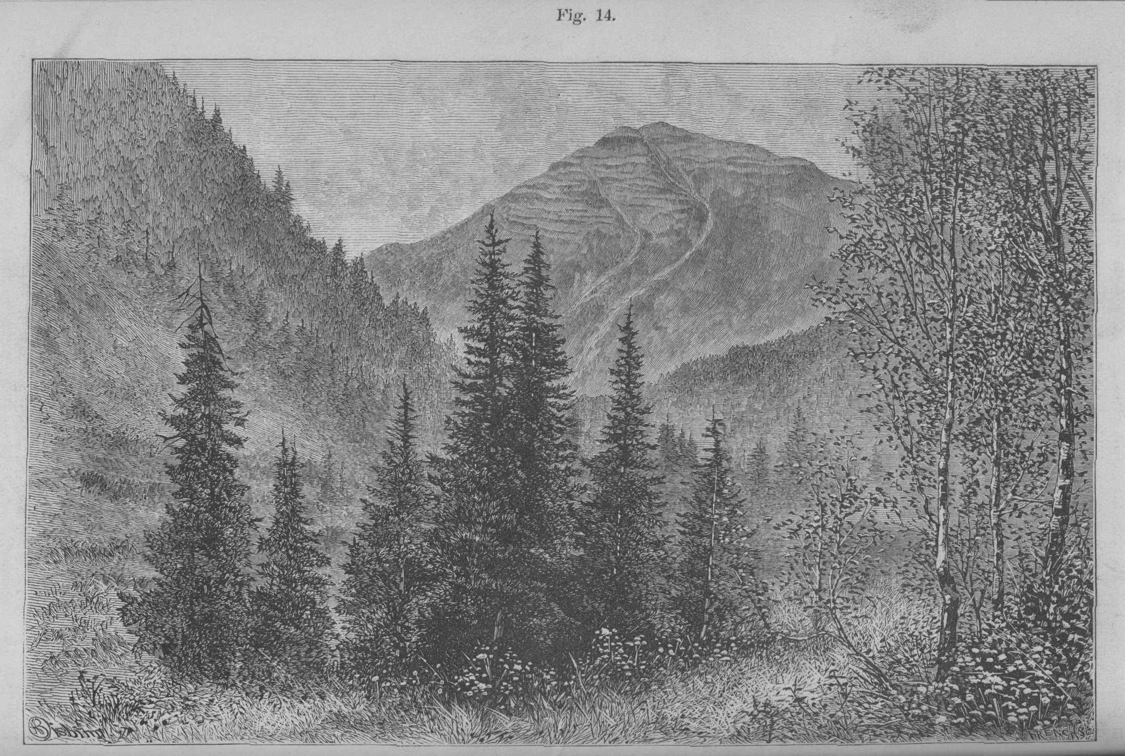

Teocalli Mountain
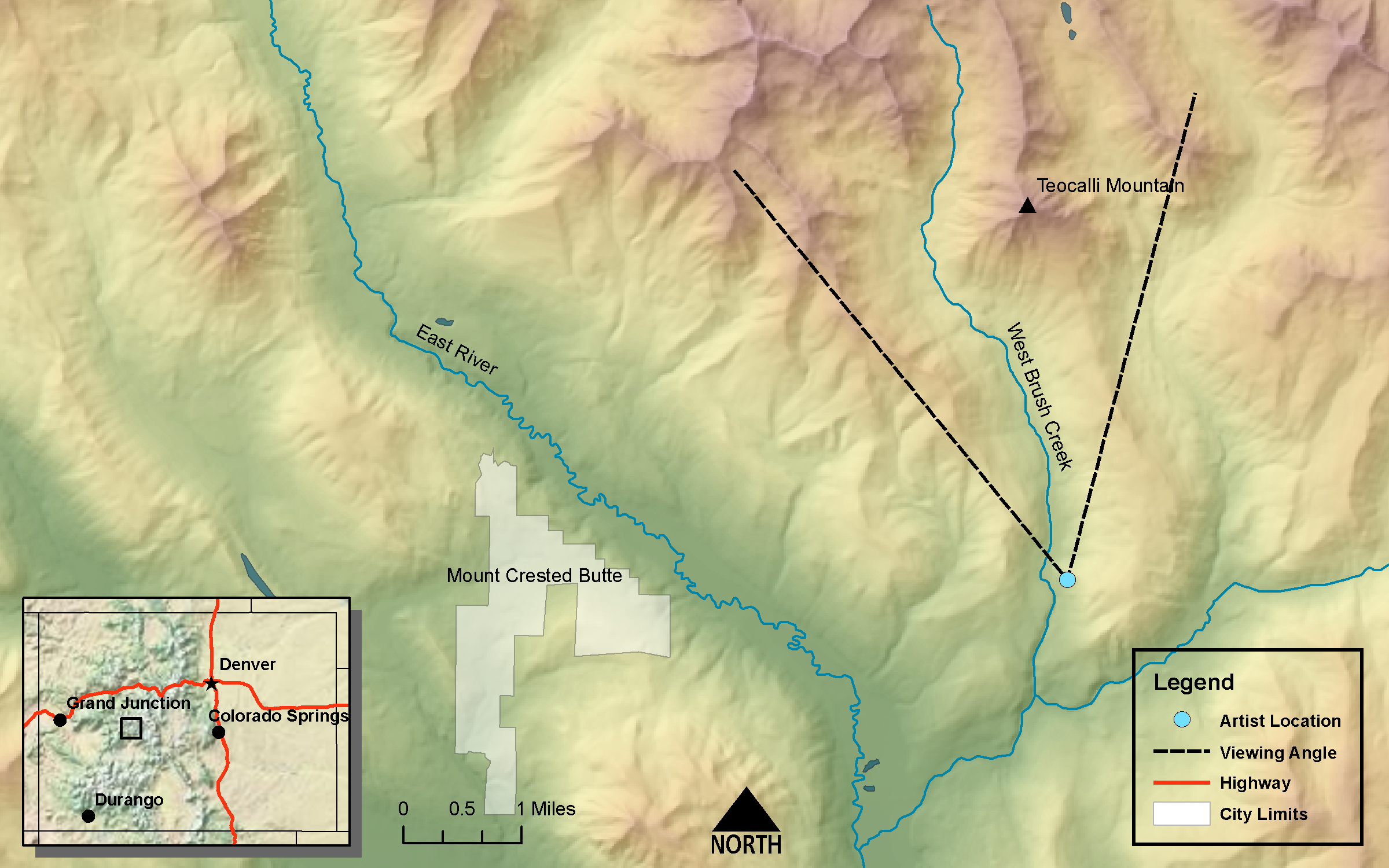
DRAWN/TAKEN FROM GEOGRAPHIC COORDINATES: LATITUDE: 38°54′58′′ N | LONGITUDE: 106°52′47′′ W | UTM zone 13N | 337,303 mE | 4,308,946 mN
VIEW ANGLE: North | COUNTY: Gunnison | NEAREST CITY: Crested Butte
The photo and drawing were taken from the West Brush Creek Valley bottom. The area is now covered with thick stands of willow. Teocalli (13,208 feet) is a dramatic mountain that is really representative of its name.
The peak named on the map as Italian Peak [sic], 13,255 feet in height, is an example of the variegated colors of the rocks, due to the flowing upward through the fissures of the melted rocks, accompanied with a force that tilted the sedimentary strata in all directions.
Annual Report for the 1873 Field Season (Hayden 1874, 58)
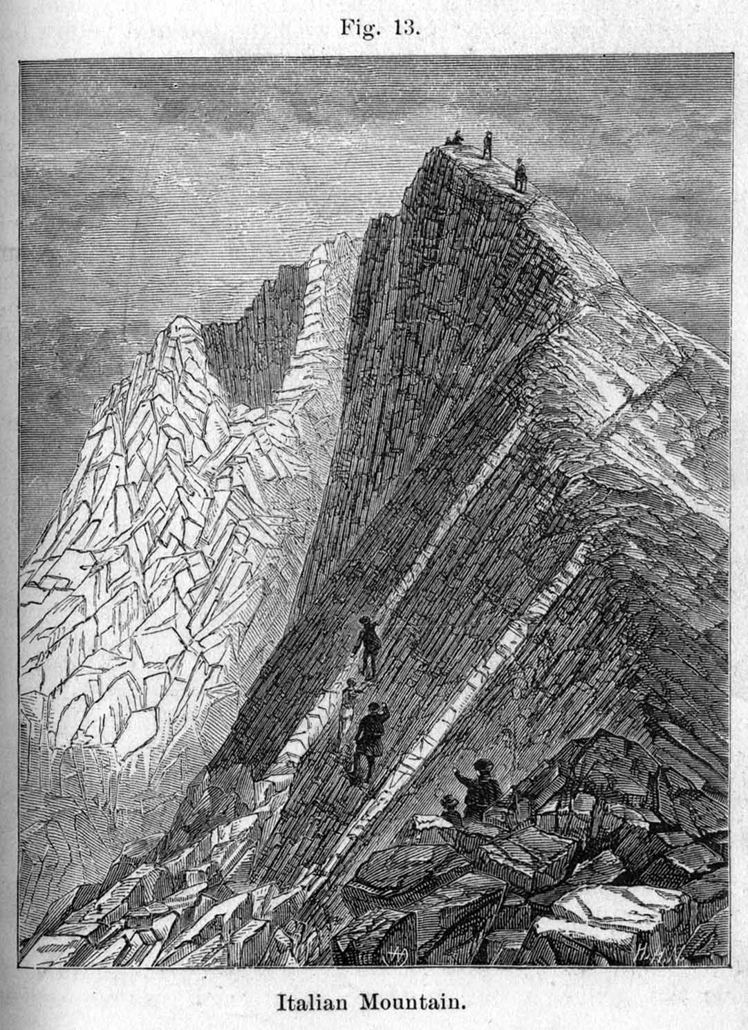
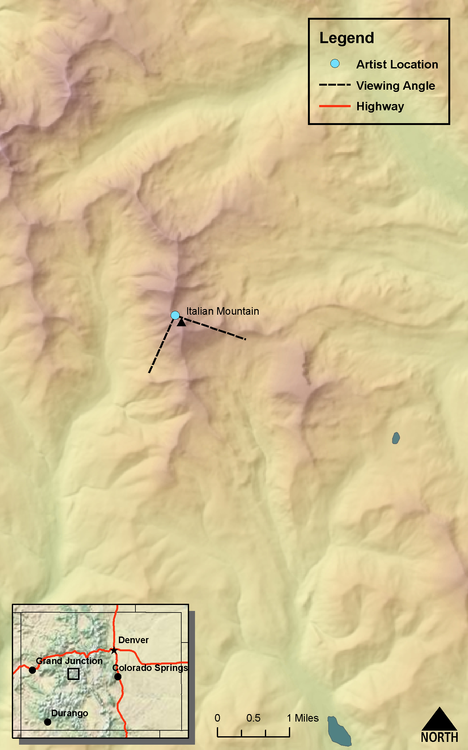
Italian Mountain
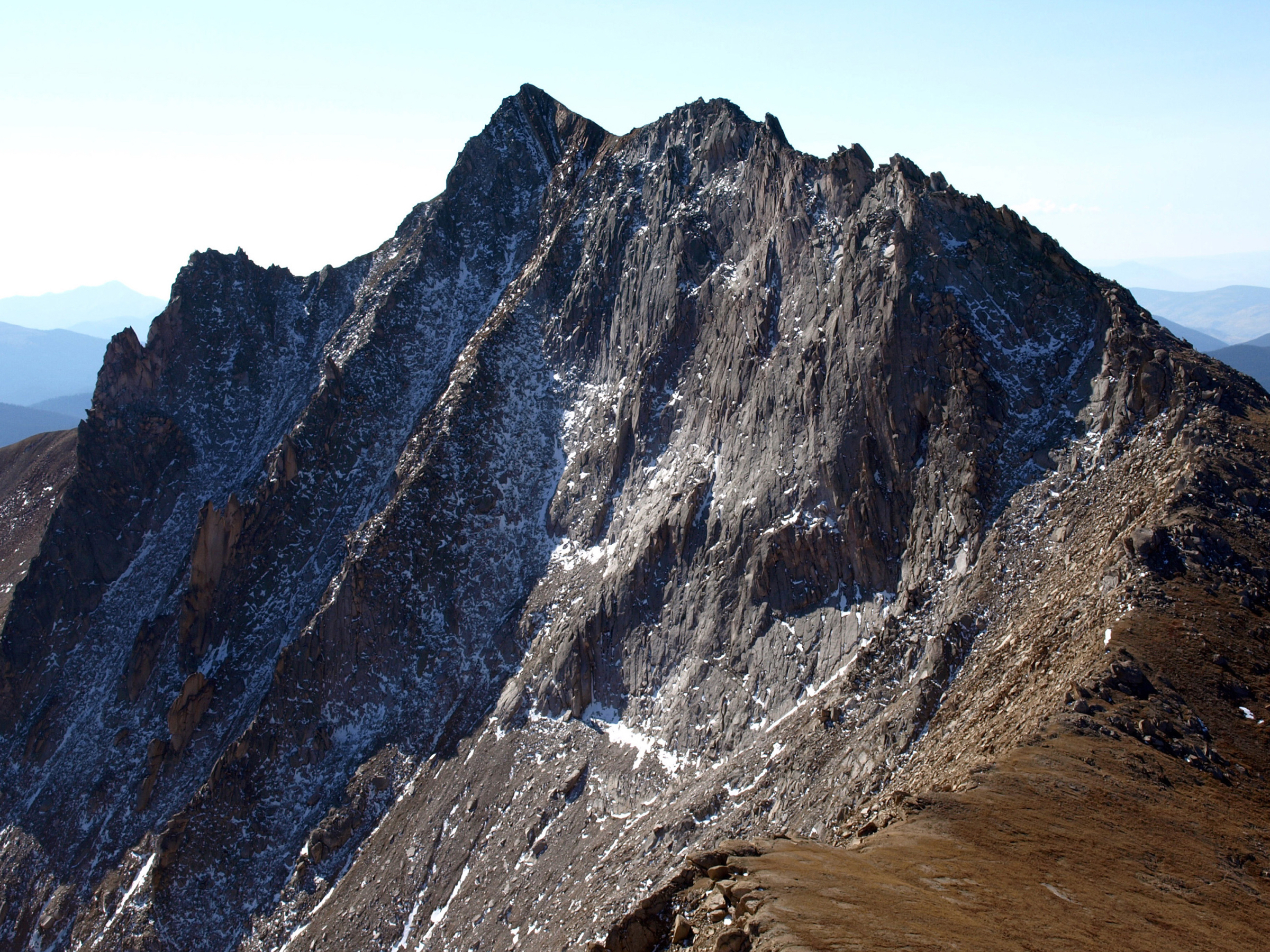
(Annual Report for 1873 Field Season Hayden 1874 - Figure 13, page 60)DRAWN/TAKEN FROM GEOGRAPHIC COORDINATES: LATITUDE: 39°57′01′′ N | LONGITUDE: 106°45′14′′ W | UTM zone 13N | 348,085 mE | 4,312,205 mN
VIEW ANGLE: South-southeast | COUNTY: Gunnison | NEAREST CITY: Taylor Park
The Italian Mountain (13,378 feet) scene was drawn with some artistic license. The view in the drawing is not possible to get because it is in midair a few hundred feet from the ridge from where the photo was taken. But the view is exquisite anyway.
Teocalli—a pyramidal house for a god of the Aztecs of ancient Mexico. Teocalli Mountain (13,208 feet) is the natural embodiment of the human-made pyramids of the Aztec priests. The best-known example of this stepped-pyramid design was the great dual pyramid Hueteocalli at the center of Tenochtitlan—the fourteenth-century Aztec capital that has evolved into the current-day Mexico City. Hueteocalli was destroyed during the Spanish conquest of the Aztecs, but its remnants were discovered in the center of the city and are now a major museum. After Hueteocalli was built, it was dedicated to the two gods Huitzilopochtli and Tlaloc. Archaeologists believe that at the temple each harvest, dozens of captive warriors were sacrificed and their flayed skin worn by the priests (Clendinnen 1991). Eerily, the blood-red rock of Teocalli Mountain evokes a specter of the dried blood of those sacrificed souls.
All of Teocalli Mountain is composed of this deep-red- or maroon-colored sedimentary rock that geologists named, for obvious reasons, the Maroon formation (see the section 12 on the Central Elks). At the time of the Hayden Survey, geologists were just beginning to understand the exact nature and provenance of the Elk Mountains in general and the Maroon formation in particular. It was obvious to Hayden and his crew that the Elk Mountains were a different creature than the majority of the mountains in Colorado. Most of the rock cores of the high mountains of the Front, Sawatch, Gore Ranges, and others were composed of Precambrian crystalline rock—mainly granites and metamorphics. The eastern and northeastern portions of the San Juan Mountains were mostly volcanic in origin. But the core of the Elks was made up primarily of sedimentary rocks, which usually do not make up many high mountain systems because they erode more readily than the more erosion-resistant crystalline rock. Most of the sedimentary rocks of the Elks are Pennsylvanian to Permian (250 to 300 million years ago) in age and correspond to the uplift of what we now call the Ancestral Rockies.
The line drawing clearly shows the horizontal strata of the Maroon formation on Teocalli Mountain quite well. The two curving drainage channels are also portrayed distinctly. These two features are certainly visible on the current photograph, although each is a bit more subdued than in the drawing.
The big differences in the scene lie in the foreground. In Hayden’s time, the valley bottom of West Brush Creek had clustered stands of Engelmann spruce and aspen. These Engelmann spruce may well have hybridized with the Colorado blue spruce—a close relative that thrives in wetter soil conditions. The areas between these stands were relatively open and filled with grasses, forbs, and low-lying shrubs. If the drawing is accurate, and there is no reason to think otherwise, the current photo shows that the Engelmann spruce stand has been altered only slightly. The two trees on the right must have died and the others have grown over the ensuing 130 years or so. The growth rate of these spruces is very slow in this environment. These trees have only grown a maximum of about fifteen feet, some of them considerably less.
Why the slow growth rate? At least two factors are responsible for this meager increase in height. First, this scene is at an elevation of about 9,600 feet. Winters are brutal and last for months at this elevation. The temperatures are very cold here, especially at night when the colder, denser air drains into the valley bottoms. Some of the places that record the coldest temperatures in Colorado—such as Gunnison, Alamosa, and Fraser—are in deep mountain valleys. The second factor is that there is probably too much moisture for the spruces. Engelmann spruce do not tolerate well the wet or saturated soil of this valley bottom. In the recent photograph, the open land is now covered in willows—a sure sign that the ground is nearly always wet and often saturated. Willows thrive in this environment as opposed to the spruces’ retarded growth rate.
The valley of West Brush Creek was obviously glaciated with its relatively flat valley floor and the U-shaped cross-section. In many of the stream reaches, the downstream gradient is low, and the creek meanders and anastomoses across the bottomland. A great deal of moisture-holding sediment from the long-gone glaciers and subsequent alluvial deposition has added to the lushness of the valley’s vegetation. The conditions here are often soggy and perfect for willows and other plants—such as bog birch, alders, rushes, and sedges—which can tolerate the anaerobic character of saturated soil. Two main processes have been at work to change the grasslands in the valley of the Hayden Survey drawing to the willow carrs of today.
The first is that much of this reach of stream is “bogging” in (see the Twin Lakes section, 11). A bog develops as large amounts of organic matter build up from the lush vegetation. The organic matter increases and, at the same time, captures much of the sediment that is brought in by the moving water of the stream. These conditions produce a fertile soil in which plants thrive. In addition, the saturated bogs are better for willows than for grass.
A second process has been occurring only since the area has been settled by ranchers. This valley has become prime grazing land for cattle. The area is part of the Gunnison National Forest, and grazing leases have been sold to local ranchers for decades. In the summer months, cattle can be seen throughout the valley contentedly grazing the rich forage. This intensive grazing has undoubtedly stressed the original grasses and helped the transition to the ground cover we see today. There are still places in the valley with significant grass that are not adjacent to the water. Grasses in these drier places are much more tolerant of intensive grazing—if not overdone, grazing allows grasslands to remain healthy ecosystems. But in the drawing location, the bottomlands of the valley are now covered in nearly impenetrable willow carrs that have replaced the grassland.
Looking at the big picture of the West Brush Creek landscape, little has seemed to change between the early 1870s and today. Teocalli Mountain stands seemingly immutable in the background, the two drainage scars giving its face some character. The high ridges on either side of the valley appear unchanged, at least from a distance. But there are visible, irrefutable, and significant changes that have taken place even in this bucolic environment. Some of these changes are from the slow march of the natural processes of plant growth and death, erosion, and deposition. Others come directly from the intervention of humans and their agents (cattle for example). The valley still has the breathtaking beauty, the crisp mountain air, and the vibrant colors of autumn, but the natural systems have been altered in subtle and not-so-subtle ways.
Italian Mountain (13,378 feet) is included with Teocalli Mountain because these two mountains represent decidedly different aspects of the southern edge of the Elk Mountain range. And they are linked in the same section because Hayden discusses the miles-long ridge that connects the two mountains. Teocalli is the quintessential red-rock mountain of striking horizontal strata, much like the more famous Elk Mountains to the north such as the Maroon Bells and Pyramid Peak, whereas Italian Mountain is nearly the antithesis of that. There is hardly a red bed to be found near Italian; rather, one finds nearly indecipherable geologic complexity. Hayden himself wrote this part of the 1873 field season Annual Report. His assessment of Italian Mountain is that, “the upthrust of the igneous rock has produced great chaos in the beds” (Hayden 1874, 58). That is about as simple and powerful a statement as one will get from Ferdinand Hayden in any of his writing.
In the same paragraph as the quote above, Hayden talks about the Silurian quartzites being intruded by igneous dikes. Hayden was correct in recognizing the dikes and the innumerable intrusions in this area, but identifying the time period as Silurian is a mistake he and his survey make throughout all his publications. This was excusable, as there are few good fossil occurrences that to date rocks as Silurian. In fact, it was nearly a hundred years before any rocks of the Silurian period were found in or near Colorado. The only remnant of this geologic period is a small outcrop along the Front Range near Wyoming. Without that evidence, we would not know that Colorado had been covered by a large sea, with its attendant deposits, during the Silurian. Almost all other evidence of this sea has been eroded away, and the Silurian is, in essence, a major missing period or unconformity (called a disconformity in this case) in Colorado geologic history.
The actual geology of the Italian group of mountains is a collection of quite different rock types and structures. The core, as with many of Colorado’s mountains, is an ancient granite which has been dated at 1.4 billion years old (bya). This core has been thrust up from deep below the surface in each of the various mountain-building episodes and eroded down each time. But overlying most of the igneous core are several types of sedimentary rock, mostly of Devonian through Permian age. These consist of shale, sandstone/quartzite, and limestone beds. Normally these would lie in horizontal positions where they were deposited and lithified. But here there are uncountable small and large fractures and faults in addition to a large number of Tertiary volcanic extrusions that form dikes that are from four to forty feet thick. The volcanics along with the complex fault system has turned many of the formerly horizontal sedimentary beds to nearly vertical. The intrusions also produced some very localized contact metamorphism and, more interestingly, allowed superheated fluids to bring up mixtures of minerals that make this area a gem/mineral collector’s dream. There are at least eighty different types of gems in the Italian Mountain vicinity; the most common are lazulite, garnet, and epidote. There are some small mines still operating in the area producing lead, zinc, and silver in limited amounts.
The drawing of Italian Mountain is an intriguing one. It is certainly one of the most dramatic of the smaller illustrations in the Reports with the near vertical, upturned beds and an intrusive dike on the left-hand side. The presence of humans walking/climbing on these precipitous slopes adds some interest, although it is not clear that people would actually be on these slopes without some sort of climbing gear and protection. When you compare the drawing with the photograph, it is obvious that a significant amount of vertical exaggeration was used by the original artist. It would be impossible to get the exact replication of the drawing with a photo unless the photographer were suspended in midair to the right of the scene. Despite the artistic license of the artist, and the difficulty in trying to get the correct visual angle to photograph, this was one of the most exhilarating places to photograph for this project. The views from here are stunning and expansive, and as Hayden himself says, “From this peak we have a most remarkably extended view on every side” (Hayden 1874, 60). One can see the Maroon Bells, Snowmass Mountain, of course Teocalli, Crested Butte, the entire western mountain front of the Sawatch Range, the upper Taylor River Valley, and the upper Cement Creek Valley.