They constitute a pretty distinct group, the most westerly of the San Juan system of mountains (talking about the San Miguel Mountains), and form the extreme western angle of the great Colorado highland. There are three distinct groups, the eastern one being the principal; of this Mount Wilson is the chief summit, and “Lizard’s” [sic] Head the most easterly summit. . . . To the eye, a more lovely region than that about these mountains cannot be found.
Annual Report for the 1876 Field Season (Hayden 1878, 193 and 195)
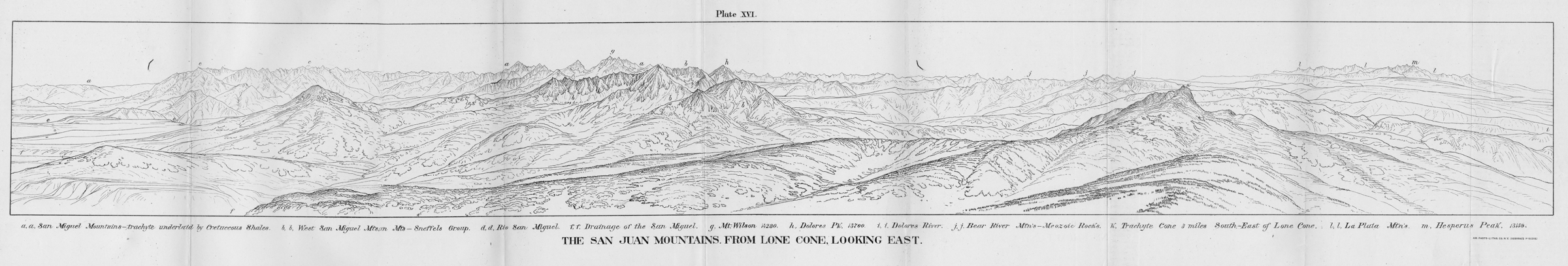
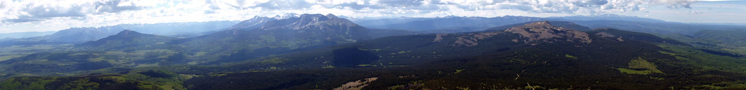
The San Juan Mountains from Lone Cone, Looking East
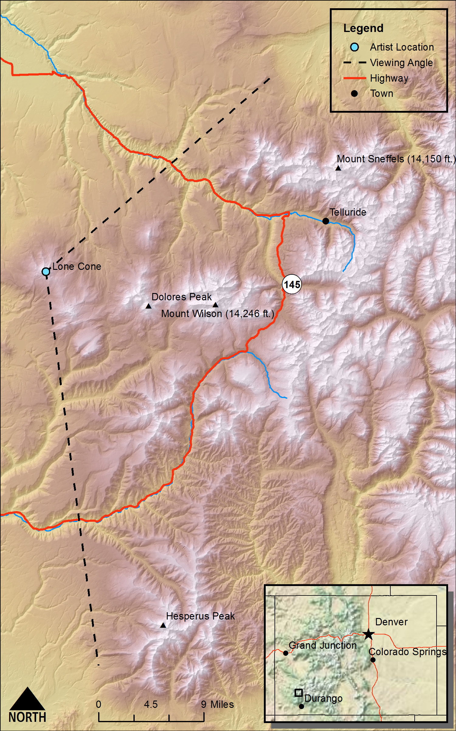
DRAWN/TAKEN FROM GEOGRAPHIC COORDINATES: LATITUDE: 37°53′17′′ N | LONGITUDE: 108°15′18′′ W | UTM zone 12N | 741,473 mE | 4,196,752 mN
VIEW ANGLE: Northeast clockwise through east-southeast | COUNTY: Dolores/San Miguel | NEAREST CITY: Norwood
This sketch, drawn from the top of Lone Cone (12,613 feet), shows the entire San Miguel Range (often called the Wilson group). The San Miguel Mountain Range is the most southwestern of the several subranges that make up the greater San Juan Mountains.


Lizard's [sic] Head
(Annual Report for the 1874 Field Season Hayden 1876 - Figure 2, page 207)DRAWN/TAKEN FROM GEOGRAPHIC COORDINATES: LATITUDE: 37°47′39′′ N | LONGITUDE: 107°56′06′′ W | UTM zone 13N | 241,461 mE | 4,186,910 mN
VIEW ANGLE: North-northwest | COUNTY: Dolores/San Miguel | NEAREST CITY: Ophir
Lizard Head (13,113 feet) is one of the most recognizable landforms in Colorado. It can be seen and recognized from almost any peak top in the San Juans, but it is hidden from the top of Lone Cone by the rest of the San Miguel Mountain massif.

The San Miguel Mountains are the far western group or subrange of the much more extensive San Juan Mountain system. But this tightly packed collection of high peaks is as dramatic a landscape as can be found in Colorado. William Henry Holmes quote above is not an exaggeration—“a more lovely region than that about these mountains cannot be found” (Hayden 1878, 195).
The landscape plate of the San Miguel Mountains from Lone Cone was done as part of Holmes’s survey division during the 1876 survey season. The drawing runs from looking northeast beyond Mt. Sneffels near Telluride to nearly due southeast and beyond Hesperus Peak [(m) on the panorama] in the La Plata (l) subrange of the San Juans. The most vivid section of the rendering is the center, where Mount Wilson (g) is the focus. Mount Wilson (14,246 feet in today’s measurement [the figure on the map is incorrect]) is the tallest of the San Miguel Mountains; the topographers of the Hayden Survey put it at a surprisingly accurate 14,280 feet. The two other 14ers in the San Miguel Range, Wilson Peak (14,017 feet) and El Diente Peak (14,159 feet), are not marked on the scene but lie just to the left and in front of Mount Wilson respectively. Both Mount Wilson and Wilson Peak are oddly named after the same person—A. D. Wilson, who was the chief cartographer of the survey at the time. There have been several failed attempts to rename Wilson Peak. Dolores Peak looks very near this concentration of 14ers, but it lies about five miles directly west of the group. Lizard Head, which will be discussed below, is hidden by the mountain mass of the Wilson group but can be seen from the east side of the range.
Geologically, all the higher mountains in the center of this drawing and Lone Cone, from which it was drawn, consist of volcanic rock at times interbedded with the country sedimentary rock. Holmes and the Survey call all this volcanic material Tertiary trachyte. Trachyte is defined as a light-colored felsic, extrusive rock with a considerable amount of alkaline feldspar incorporated into its mineralogy. The more modern terminology on current geologic maps refers to this formation as intermediate to felsic volcanic rock of the Tertiary period (20 to 40 mya). Felsic is a term used to describe continental plate igneous rock that is high in quartz and numerous feldspars; it is usually acidic versus the basic (basalt) igneous rock that occurs within so many of the oceanic plates. A striking pattern in this area: if you look at a modern geologic map these volcanic uplands look as if they are floating in a sea of horizontal, older Cretaceous shale beds—in this case the ubiquitous Mancos shale found throughout western Colorado. There are also a few erosion-resistant outcrops of the Dakota sandstone. Some of the shale has been locally metamorphosed (contact metamorphism) by the heat from the extrusive volcanic material as it erupted and injected itself into the flat-lying sediments. Rock samples on Lone Cone slopes typically have a complexly mixed combination of shale, felsic volcanic material, and slightly metamorphosed material.
Although Lizard Head is only just over 13,000 feet (13,188 feet to be exact), it is such a dramatic landform that it is recognizable by most people as they drive up and over Lizard Head Pass south of Telluride and Ophir. It is not a volcanic neck as it might appear. It is a feature made up of many separate layers of welded volcanic tuff which is the pyroclastic equivalent of the flows we see in the high mountains just to the west. Lizard head was sketched by the survey because of its stunning protrusion, but little was actually written about it in any of the survey’s Annual Reports save that it is definitely a part of the San Miguel group of mountains.
To the large flock of mountaineers in Colorado, the San Miguel Mountains are a mecca for difficult and rewarding climbs. Mount Wilson is considered one of the most difficult ascents of the Colorado 14ers, maybe in the top-five most challenging. El Diente Peak was for many years classed as a mountain as challenging to climb as some of the more difficult Alps. It was probably the last 14er in the state to be scaled. And Lizard Head was thought to be nearly unclimbable. According to Blair 1996 an early guide to climbing in Colorado recommended that groups that envision climbing Lizard Head should hike to its base, take a photograph, and hike back out. It was climbed in 1920 and remains one of the premier mountain ascents in all of Colorado.
The Hayden Survey, of course, was much more than a geological investigation. Indeed, one of its most important goals was to produce topographic maps of the territory/state that were reliable and accurate. The travails of this work are discussed explicitly in the survey’s experiences taking place during the topographic work in the San Miguel Mountains, specifically in climbing Mount Wilson. In the Annual Report for the 1874 field season, Franklin Rhoda, the Assistant Topographer, wrote “Only one peak of which we had any dread remained yet to be ascended, and that was Mount Wilson. From various circumstances we had reason to believe that this was higher than any station we had yet made, and from its rugged appearance we dreaded its ascent not a little” (Hayden 1876, 483). The station to which Rhoda was referring was one of the multitude of high points from which all the major triangulations of the state were made.
The essentials of topographic mapping include locating all the pertinent landscape elements, drawing maps that show where these places are on a horizontal surface using a common coordinate system, and determining elevation data for the land surface to add the third dimension. The work done in the San Miguel Mountains is the same as done throughout the territory/state.
The basic instruments used in the Hayden era were a plane table, an alidade, a measuring chain, and a survey or stadia rod. The plane table is nothing more than a flat board attached to a tripod onto which a piece of paper or vellum can be secured and the entire thing leveled and aligned to a high degree. The alidade is a powerful and precise telescope with measurement capabilities and a straight edge at the bottom for drawing lines/angles on the plane table. From a known point (point A) or station, as the Hayden Survey called it, where the plane table is positioned, a reading was taken through the alidade to another point (point B) at some distance where the stadia rod was being held. A line was drawn on the plane table from A to B. The distance between the two points could be measured with the chain, called such because it was usually a metal chain of precisely known length. If the distance was too far for “chaining,” distance measurements were taken using an odometer pulled behind a mule or off of markings on the stadia rod and calibrated etching marks within the alidade. The same process was continued for a third point (C). To determine the accuracy of both newly measured points (B and C), a reading was taken from C back to A—closing a triangle. The trigonometry should be such that the distances and angles would all be accurate as the triangle was closed. This process is/was called triangulation for obvious reasons. There are many, many more technologically and accurate methods for doing triangulation today, but the mathematical concepts are the same now as then.
A mule-drawn odometer
The first task for the Hayden Survey at the very beginning was to establish an accurate baseline of exactly known length and two end points of the line that were also precisely located. This baseline was established near Denver the first year of the survey. From that line and the two known end points, with a few exceptions and adjustments, triangulation was performed for hundreds of points throughout the territory/state. Most of these points were positioned on higher terrain, which allowed sightings between points to be done without interference by intermediate landforms. The result of the Hayden triangulation efforts was a map of Colorado published in the Geological and Geographical Atlas (Hayden Survey 1877) that shows all of the major “triangles” produced through the extensive triangulation network of the survey.
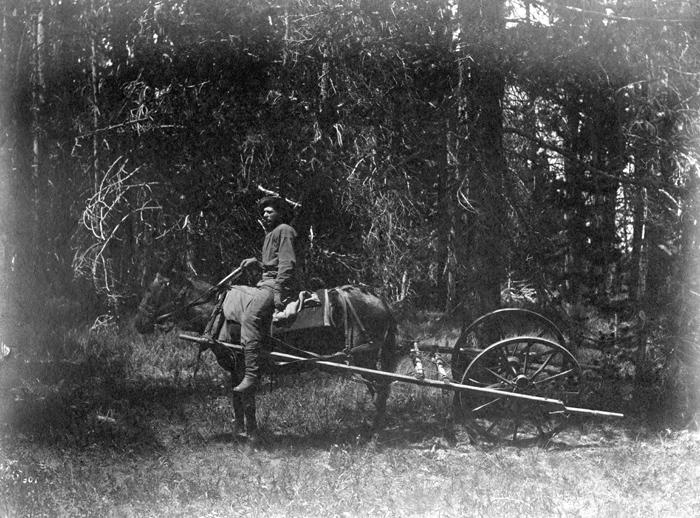 A mule-drawn odometer
(photo by William Henry Jackson, courtesy of the US Geological Survey Denver Library) This is an example of the mule-drawn odometer the survey used in certain circumstances to get approximate distances over long traverses, 1871.
Most of the details drawn on the other final maps in the Atlas such as roads, creeks, settlements, and so on were done using the triangles as reference. Few features were “exactly” located, but they were very close and any more accurate mapping would have needed an immeasurable amount of time and effort well beyond the capabilities of the Hayden Survey. Remember, the survey only lasted about four years, and was composed of twenty to fifty men who rode mules in an area without many roads. And the work on the ground could only be done in the summer because of weather. The final product was amazingly accurate and done incredibly fast considering the technology of the day and the resources expended on the effort.
The vertical measurements of the topography were made using two different methods, and even the Hayden topographers were never really satisfied by the results of either method. Newer technologies such as photogrammetry and global positioning systems (GPS) were not available. It took decades and great leaps in technology to do a much better job of measuring elevations. But even today with sophisticated GPS satellites, there are still arguments about elevations in Colorado—most of these current discussions are centered on the heights of some of the 14ers of the state.
The first method used by the Hayden Survey was nothing more that getting elevations from a mercury barometer. Apart from the difficulty of hauling a glass barometer around in very rugged terrain, there was the problem of air pressure variations itself. The concept of getting elevations from barometers is straightforward. As one increases in elevation, the barometric pressure decreases at a known rate; this rate is defined by an exponential curve. The problem is that this curve is only theoretical and many factors contribute to its inaccuracies. Daily, even hourly, changes in atmospheric pressure occur all the time with the movement of weather fronts and low and high pressure systems in flux.
In essence the survey would take an already-known elevation and get a barometric reading at that spot. They would get another barometric reading at a spot of unknown elevation and use the difference between the two barometric readings to calculate the elevation difference between them. Often they would do this multiple times to get an average reading before assigning an elevation to the unknown place.
The second method used for elevation determination was to use some of the capabilities of the alidade and stadia rod. In addition to its telescopic properties, the alidade had angular calibrations that could be read as the instrument was angled up or down in comparison to the flat plane table. These angular measurements could be made in degrees and minutes. If a point at a known distance was so many degrees/minutes above or below the alidade, the elevation difference between the two places could be done using a simple trigonometric calculation. At least two problems existed that diminished the accuracy of these elevations. First, even angular minute readings were gross approximations, and more precise second readings that would be required for more accuracy were not feasible with the equipment of the day. Second, heating and cooling of the air creates waves that affect how light passes through it. The refraction of light because of these atmospheric perturbations over long distances made readings difficult and frustrating. Given all of these practical and scientific complexities, the mapping work done by the Hayden Survey is a testament to the abilities and tenacity of the entire survey membership.
There are a multitude of beautiful mountains in Colorado. But William Henry Holmes seems to have selected the San Miguels as his choice. He would be hard to argue against.