A general view, obtained from the summit of Lone Cone, shows it to be plateau-like in general, cut by deep gorges or canons toward the east, and rendered somewhat irregular toward the west by several broad folds. Near Lone Cone Mountain the country is somewhat hilly, and in places mesa-like.
Annual Report for the 1876 Field Season (Hayden 1878, 163)

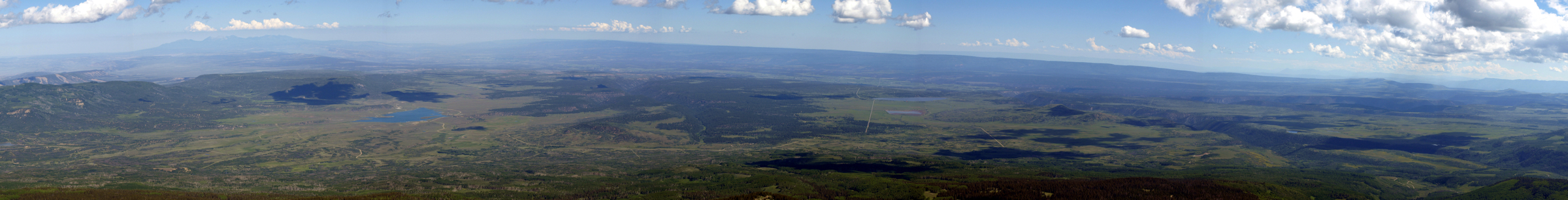
View of the San Miguel Plateau from Lone Cone
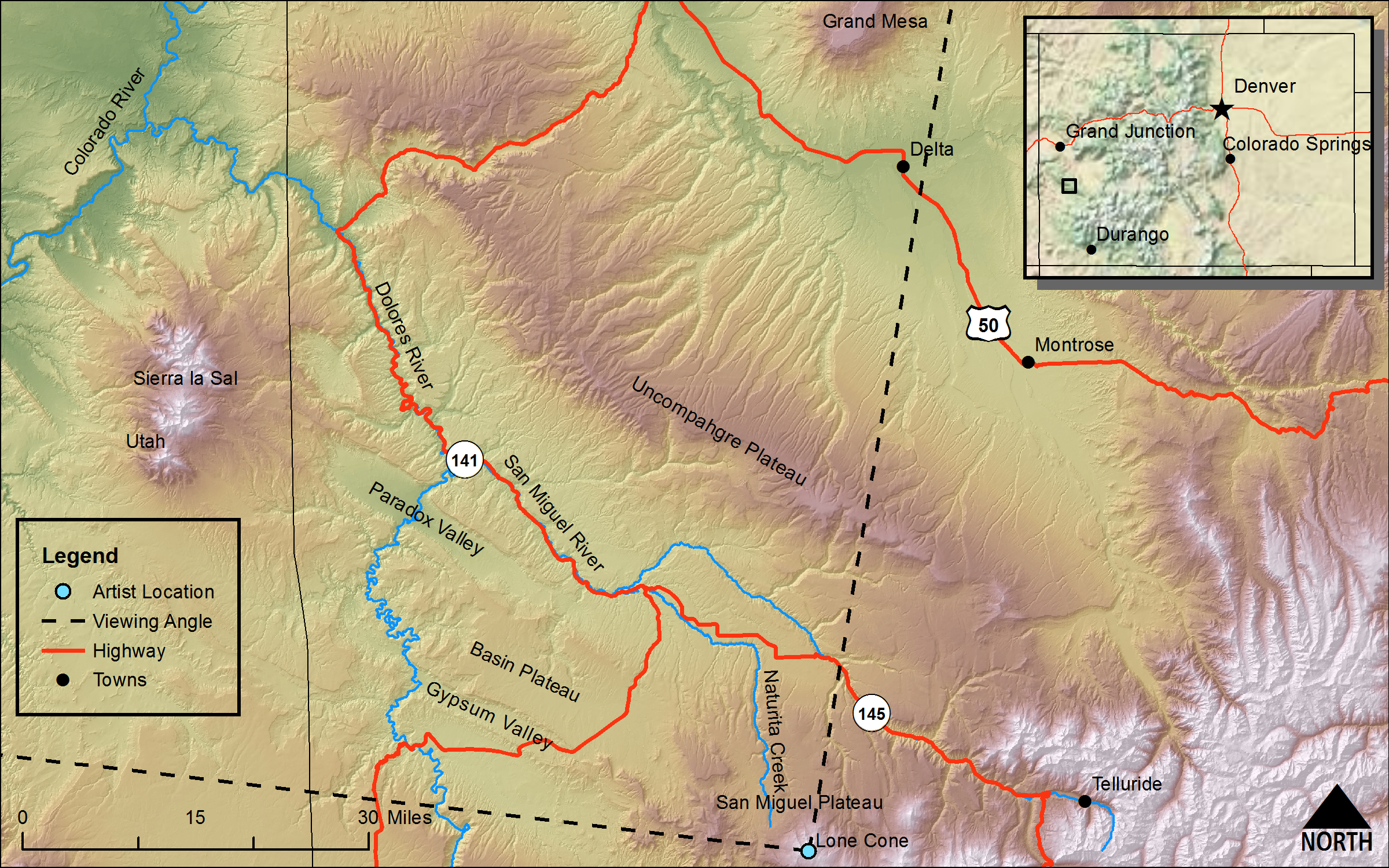
(Annual Report for the 1876 Field Season [Hayden 1878], Plate X, Figure 1, page 175)DRAWN/TAKEN FROM GEOGRAPHIC COORDINATES: LATITUDE: 37°53′17′′ N | LONGITUDE: 108°15′18′′ W | UTM zone 12N | 741,473 mE | 4,196,752 mN
VIEW ANGLE: West-southwest clockwise through northwest | COUNTY: Dolores/San Miguel | NEAREST CITY: Norwood
The San Miguel Plateau spreads out in an expansive view toward the larger Colorado Plateau. This land of mesas and canyons is rugged in its own way even though the vertical nature of the mountain scenes is missing.
The two major landscape drawings done from the top of Lone Cone probably could not have been more different. The drawing looking toward the east, done by William Henry Holmes (see section 17, on the San Miguel Mountains), is a mass of high, rugged mountain summits showing the intense, localized orogenic forces that created them. This drawing, looking from Lone Cone toward the west-northwest done during the same field season (1876) by F. D. Owen, shows the subdued landforms of the nearly flat-lying sedimentary beds etched by deep canyons and valleys. The uplifts seen in the San Miguel Mountains are obvious; the epeirogenic (see below) uplifts in the San Miguel Plateau are only evident if one knows the elevations of the plateaus and mesas and considers the depths of the canyons created by the rapid erosion that only sudden and significant uplifts can promote.
Lone Cone itself is like an island of geologically recent and high volcanic material injected into the overlying sedimentary rock. It is more resistant to erosion than most of the surrounding terrain because the volcanics are harder than the surrounding sedimentary rock. The sedimentary rock, however, is not uniform in its erodibility. Some of these sediments, such as the Dakota sandstone, are quite resistant to erosion, while the Mancos shale is orders of magnitude weaker. But the topographic evidence of the resistant, horizontal beds of the sandstone is much less dramatic at the grand scale than the orogenically derived high mountains.
The very generalized differences between the intense and localized uplifts (orogenies) of the mountains and the broader, regional uplifts (epeirogenies) of the plateau province are easy to see. The regional epeirogeny of the Colorado Plateau is akin to lifting an entire layer cake that still sits on the platter where an intense orogeny is more like a finger or fist pushed up through the layers and disrupting the horizontal strata of the cake. In many cases of orogeny, there is also in injection of igneous material into the area of uplift.
The Colorado Plateau covers large parts of four states: Colorado, Utah, New Mexico, and Arizona. Colorado’s portion is relatively small with the Uncompahgre Plateau [(m) on the panorama] being the largest part of the entire Colorado Plateau in the state. The Uncompahgre can be seen in the background of the sketch. The San Miguel Plateau is a much smaller area to the southwest of the Uncompahgre. In fact the name San Miguel Plateau is nearly abandoned today. The name was coined by the Hayden Survey, and it never really stuck. Maybe this is because of the complexity and fragmentation of what was called the San Miguel Plateau. Because of this nonuniformity, modern geologists and geomorphologists find the name inappropriate.
Plateaus of the American Southwest in general, and the San Miguel Plateau in particular, are geologically young topographic features. Most were formed from a few million years ago to just a few tens of millions of years ago—merely young children in geologic time. But the rocks that make up the landforms are all much, much older. Some of these are on the order of hundreds of millions of years with even older, usually intrusive rocks at the very base of the plateaus that may be more than a billion years old. In the Colorado Plateau only the deepest erosion cuts or canyons actually get down to the deeply buried Precambrian crystalline rock formations. These older rocks are revealed as erosion cuts down into the plateaus as they are being raised up. John Wesley Powell had a geologic maxim that said that the faster something is uplifted, the faster it is eroded. He goes on to state that there are no old mountains (plateaus in this case), only old rocks. Topography can change rapidly, at least on a geologic timescale; rock formations do not.
There are two major theories that attempt to explain why this large area of the Southwest was uplifted en masse with relatively little folding or faulting—at least compared to what happens during major mountain uplifts. Neither of these theories could have been proposed during the Hayden Survey era because they both depend on elements of the modern theories of plate tectonics which have only been made possible since the 1960s through earth science technology and intensive research. The first of these epeirogenic theories is that there was a thermal thinning of the lithosphere in the Colorado Plateau region that was caused by a molten mantle plume of igneous material that moved upward from great depths below the surface. The large injection of magma from below literally pushed the earth’s crust upward in the plateau area. The second theory is that a part of a shallow, oceanic plate called the Farallon Plate was subducted from much farther west and detached under the plateau region. This intrusion of a large piece of plate material below the crust was enough to uplift the plateaus by several thousand feet.
What the Hayden Survey and this landscape drawing call the San Miguel Plateau is really one small plateau-like region and an area with several mesas. The plateau runs from the center of the drawing to the right-hand portion of the sketch and is capped by the Dakota sandstone we keep seeing in areas of Colorado covered by the survey. This Cretaceous sandstone protects the weaker rock below. The series of mesas occur on the left-hand side of the drawing, and they are composed of the Mancos shale that is exposed at the surface. These mesas are erosional remnants of the nonresistant Mancos lying atop the Dakota and are dissected by innumerable small streams that all eventually flow into the main waterway for the area, the Dolores River (d). In the background of the drawing/photo is the much larger and more well-defined Uncompahgre Plateau. And in the far-left background are drawn in the high summits of the Sierra La Sal (the La Sal Mountains) (l) in eastern Utah.
The naming of the landform features in the drawing is intriguing. Maybe more than in any other area the Hayden Survey studied, the names in this corner of Colorado are descriptive and practical. Take the Paradox Valley (e), for example. Valleys in any landscape have, or have had at some time in the past, a stream running through them; the erosion by the stream is what makes the valley a valley. The Paradox Valley has a topographic remnant of just such a paleostream, but at present the stream (the Dolores River) in the valley runs across the valley from side to side. This is the paradox. This odd drainage situation occurs because of a complex set of conditions ranging from stream capture to rapid uplift and rapid erosion. Another of these descriptive place names is the Basin Plateau (f), clearly an oxymoron. But on closer inspection, the basin is a large, broad syncline that has eroded at the edges; the main, central portion of the syncline has been uplifted with the rest of the plateau. Topographically it is high (a plateau), and structurally it is a basin (a syncline). Other expressive names include Naturita Creek (b), named by the local Native Americans of the area; naturita is the native name for the ubiquitous yucca plants that cover the land here. There is Gypsum Valley (g), underlain by the gypsum laden Hermosa formation, and the Saucer Valley (h)—no explanation needed. There is also Grand Mesa (o) and, the unlabeled in the drawing, Disappointment Valley. This landscape rendering may not be as vertically dramatic as many of the other landscapes discussed in the Hayden reports or Atlas, but it certainly rivals the other areas for its uniqueness and descriptive character.