The granites and metamorphics do not differ in many respects from those which form the nucleus of the mountain ranges generally. Reddish and gray granites form the central portions, and on the sides is a series of stratified metamorphic rocks of a great variety of structure and composition.
Annual Report for 1867, 1868, 1869 (Hayden 1873, 12)
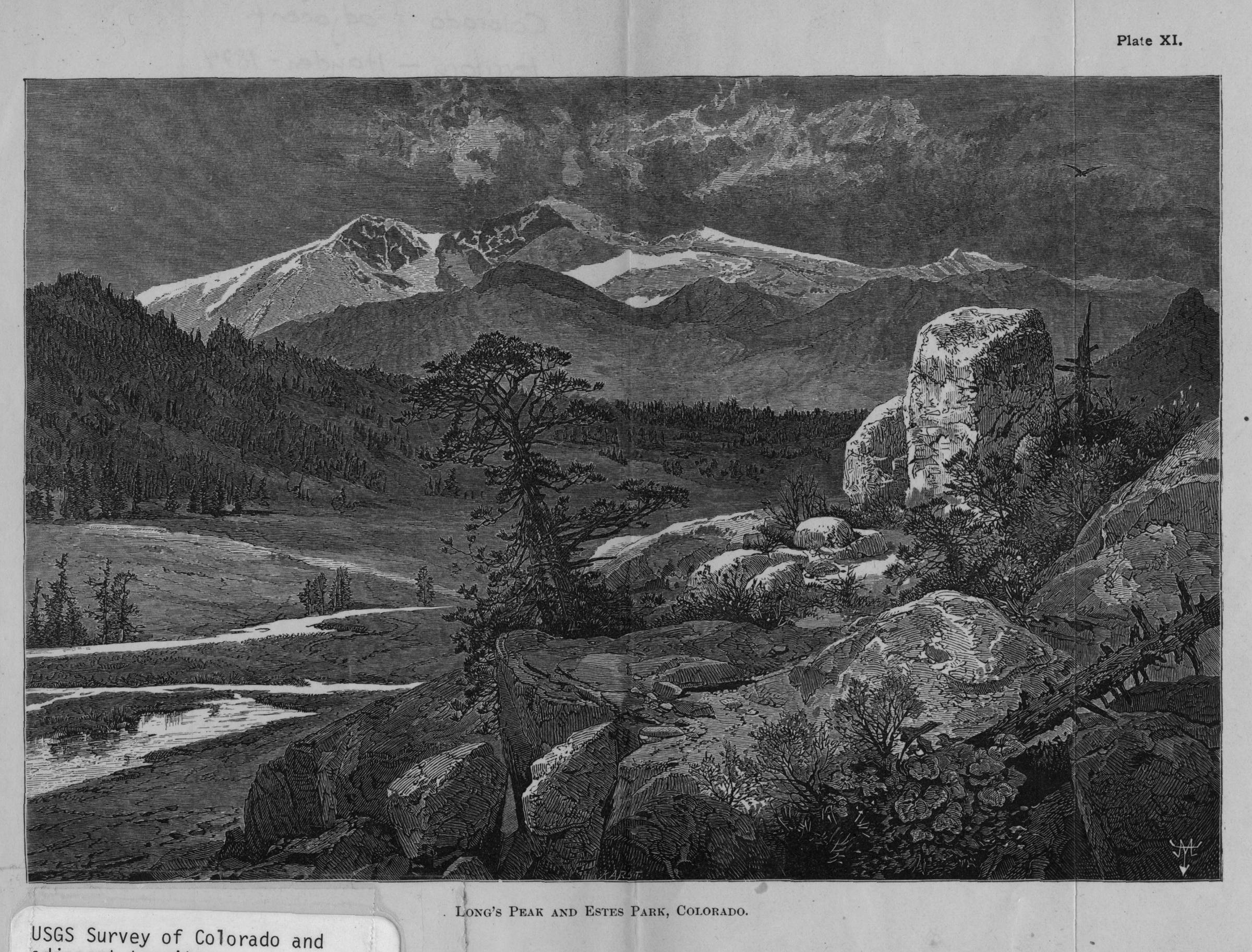
Long's [sic] Peak and Estes Park, Colorado
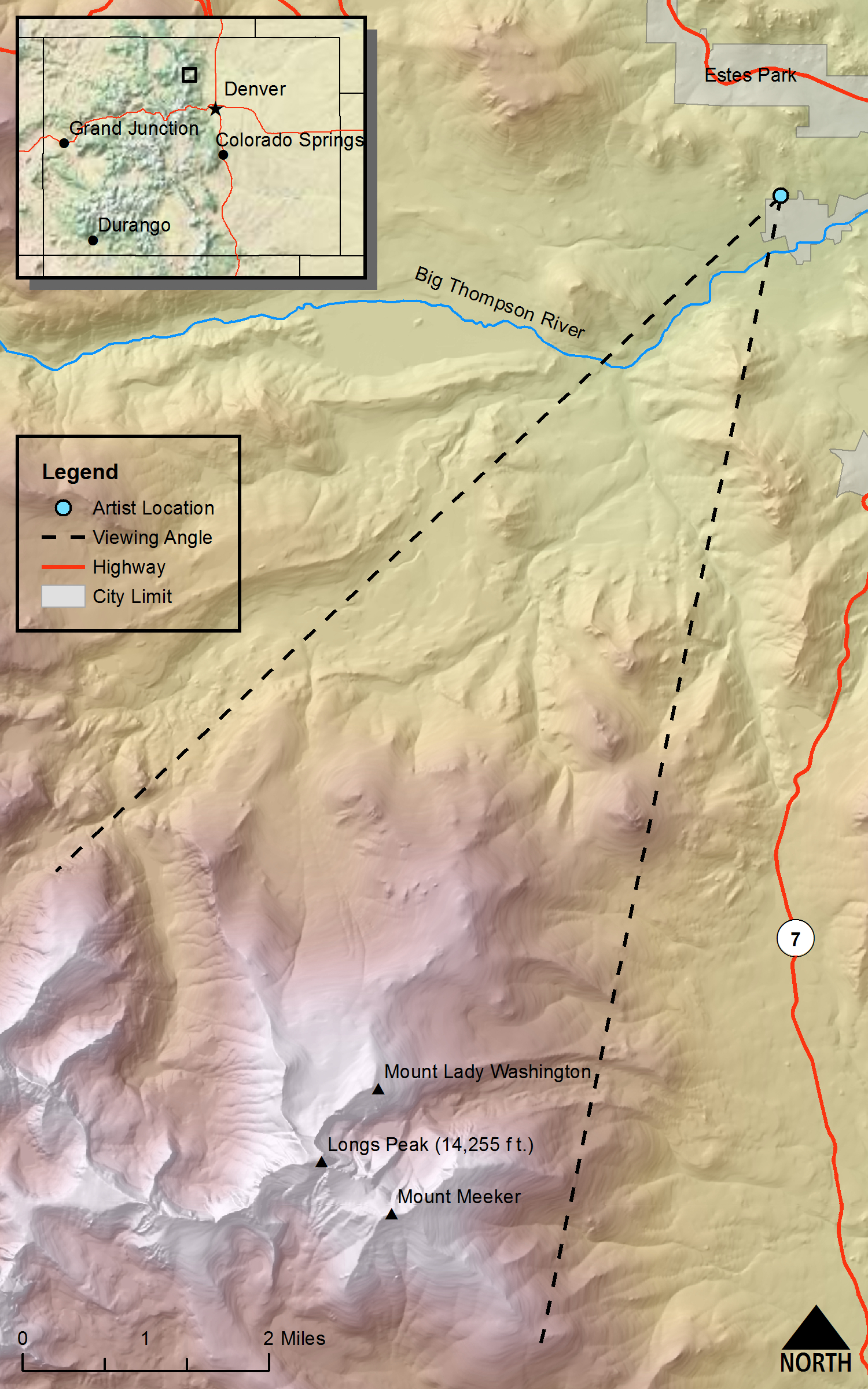
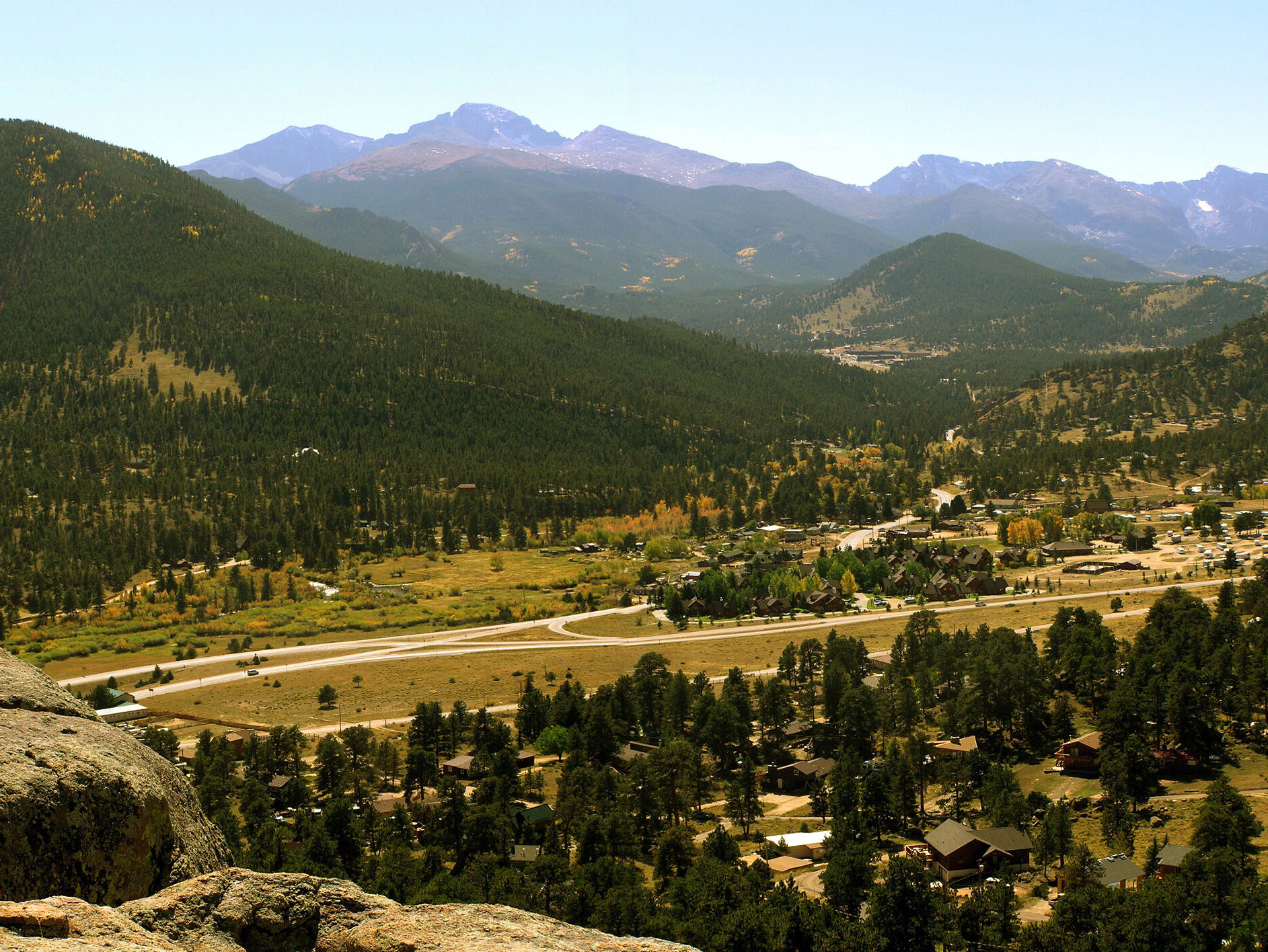
DRAWN/TAKEN FROM GEOGRAPHIC COORDINATES: LATITUDE: 40°22′27′′ N | LONGITUDE: 105°32′36′′ W | UTM zone 13N | 453,775 mE | 4,468,740 mN
VIEW ANGLE: South-southwest | COUNTY: Larimer | NEAREST CITY: Estes Park
The photo and drawing were taken from a privately owned hill on the northern edge of Estes Park proper. This is one of the Thomas Moran sketches that the Hayden Survey incorporated into their annual reports. It is slightly idealized, especially the foreground. But the essence of the Longs Peak grandeur certainly comes through.
Viewed from Middle Park, Long's [sic] Peak, and the range immediately connected with, has a rugged, saw-like edge, as if composed of eruptive rocks, and ridge after ridge inclines from it in regular order.Annual Report for 1867, 1868, 1869 (Hayden 1873, 82)
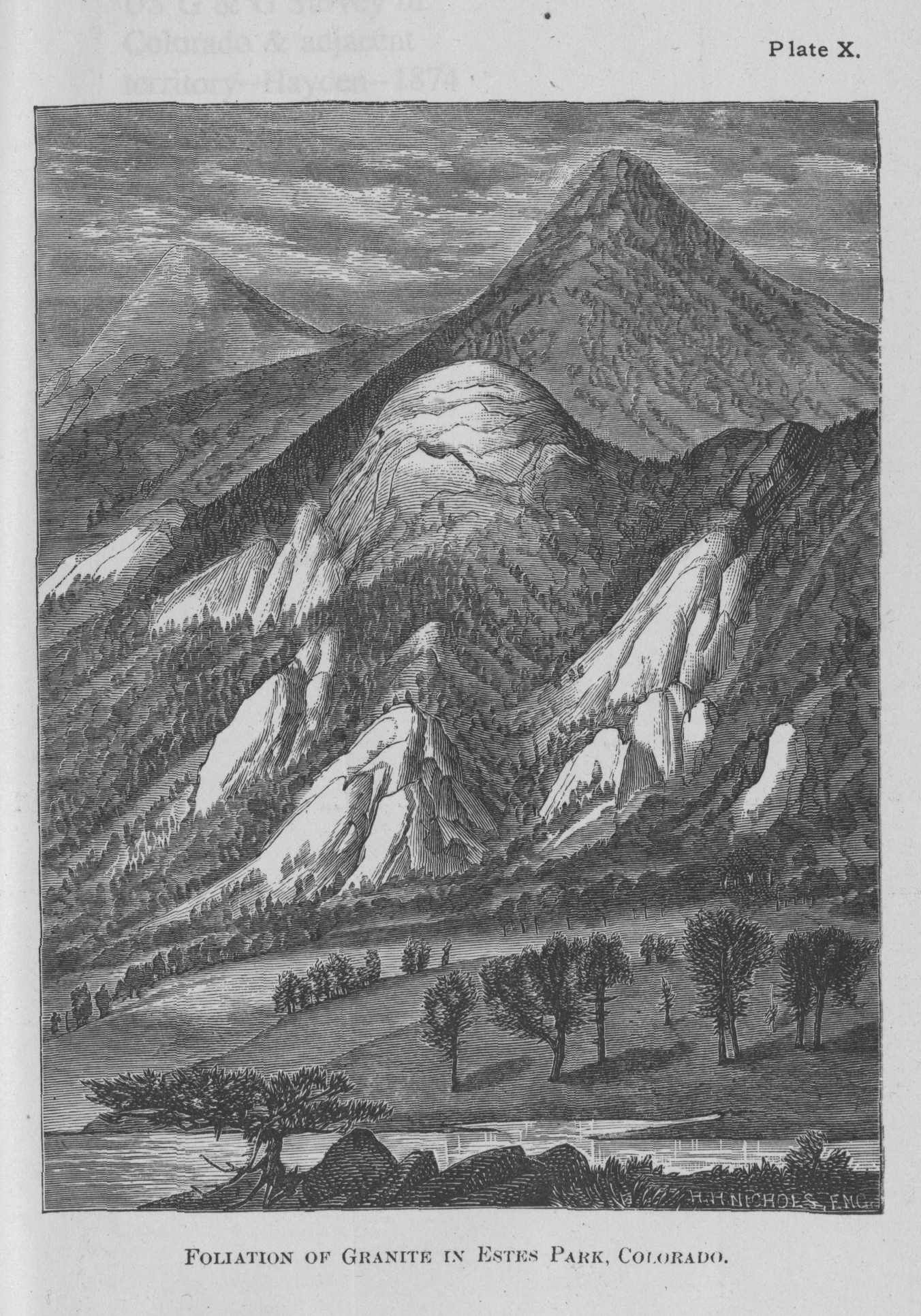
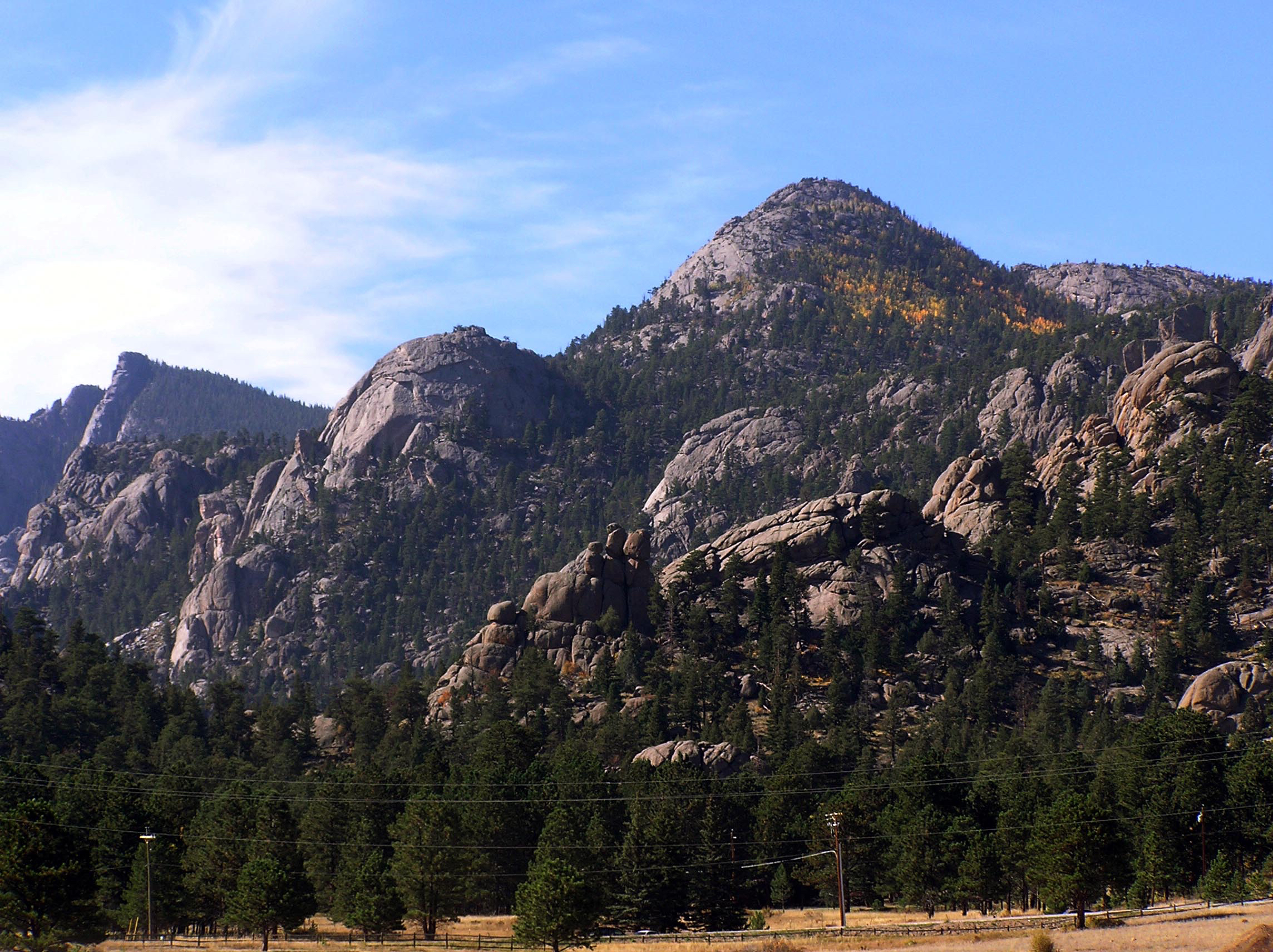
Exfoliation Domes, Estes Park, Colorado

VIEW ANGLE: West
This landscape on the southeastern edge of the town of Estes Park is world renowned for its exfoliated granite formations. The distinctive weathering patterns of exfoliation arise from massive pressure releases when the granite plutons are uplifted to the surface during mountain-building episodes.
Longs Peak (14,255 feet) is one of four mountains topping 14,000 feet that sit in the Front Range of Colorado. Its siblings are Mt. Evans (14,264 feet) and Mt. Bierstadt (14,060 feet) about forty-six miles to the south and Pikes Peak (14,110 feet), which lies west of Colorado Springs. As with the other three peaks, much of the core of Longs Peak is composed of very old granite—in this case the 1.4-billion-year-old Silver Plume granite named after the small town that lies in the mountains west of Denver along Interstate 70. Some of the oldest rock in Colorado makes up most of the rest of the peak. The metamorphic Idaho Springs formation is radiometrically dated at about 1.7 to 1.8 billion years old. All four of the Front Range “14er” peaks exhibit a flattened summit that today’s geologists often explain as an ancient erosion surface. Some 600 million years ago these landmasses were close to sea level, and their exposed upper reaches were eroded nearly flat. Subsequent orogenies have taken these planed tops to the high levels seen today.
The most recent major geomorphic agent that has affected Longs and all other high peaks in Colorado is not very evident in the sketch/photo of the peak. But if one goes nearer to the mountain, it is obvious that the dramatic erosional forces of glaciers have carved and shaped the mountain and its surroundings. The most impressive of the landforms produced on Longs Peak is its East Face—a nearly vertical wall about a thousand feet high that has become a magnet for serious rock climbers from around the world. This face is the head wall of the glacial cirque that was the upper limit of a sequence of several valley glaciers that have existed here, off and on, during the last two million years during the Pleistocene epoch (called the Ice Age in the vernacular usage). Chasm Lake sits at the base of the wall and is the tarn, or cirque lake, filling the slight depression in the cirque bottom left behind after the last glacial retreat. There is still a small remnant of a glacier left in the cirque. Mills Glacier is named for Enos Mills—the famous and often contentious “Father of Rocky Mountain National Park.” For more on the glacial epoch in Colorado, see section 10, on the Sawatch Range.
The peak was not climbed by its namesake, Major Stephen Long, who in 1820 led a government-sponsored expedition along the base of the Front Range. Dr. Edwin James of the expedition named the peak after Long. The first recorded ascent was in the summer of 1868 when John Wesley Powell led a party up the mountain. This group included William Byers of the Rocky Mountain News, whose written tales of the climb produced a rush of people to the area to climb the mountain. Hayden and men from his survey climbed the mountain in September 1873. Anna Dickinson was in this group and is acknowledged as the first woman to climb Longs Peak. She was given the honor of naming two adjacent peaks. The first she named in honor of Mt. Washington in New Hampshire but—in what might be the only feminist statement by the Hayden Survey—she named this 13,281-foot peak to the northeast of Longs Peak Mt. Lady Washington. You can see Mt. Lady Washington in the sketch/photo just to the left of the Longs Peak. The second mountain she honored was named Mt. Meeker (13,911 feet) after Nathan Meeker, the founder of the Union, or Greeley, colony on the plains of Colorado. Mt. Meeker is hidden behind Longs Peak and Mt. Lady Washington in the drawing.
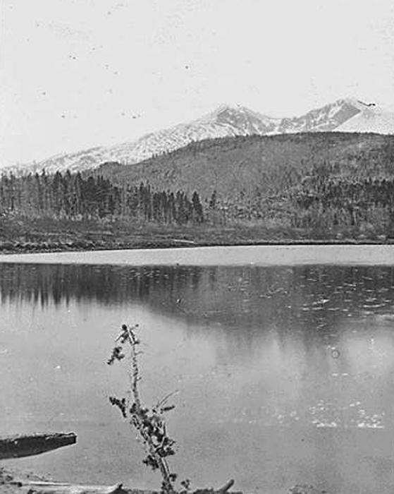 Longs Peak and Lily Lake, Larimer County, Colorado, 1873
(photo by William Henry Jackson, courtesy of the US National Archives) This area is now in Rocky Mountain National Park.
The second sketch/photo was drawn from what is now Devils Gulch Road about a mile northeast of the current downtown area of the city of Estes Park. This graphic is of the granite domes that dominate the landscape along the mountains there. These domes were all derived from the same geomorphic processes—collectively called spalling or exfoliation. Granite, by its very nature, is formed deep within the earth where the original magma cools very slowly in massive bodies under intense pressure. Usually these granite masses are well consolidated with few weak zones. When the mass is uplifted to the surface, the gigantic pressures of thousands of feet of overlying rock are released because that overburden has been removed by erosion. The pressure release allows the upper layers of the granite plutons to expand slightly upward, weakening layers parallel to the surface. These weakened sheets can then be removed by the erosional processes collectively called exfoliation. This resembles taking the layers off of an onion. The most locally famous of the exfoliation domes in the Estes Park area are the “Twin Owls”—just out of view in this rendering. These two domes are almost 400 feet high and look amazingly like two perched owls when viewed from a distance. Exfoliation is a worldwide phenomenon that can be seen in areas where there are massive granite bedrock formations similar to those here—Half Dome in Yosemite National Park is one such example, and the Sierra Nevada Mountains of California are quite famous for their extensive exfoliated granite landscapes.
The word park in Estes Park is the generic regional term for a bowl-like landform surrounded by mountains. Parks are structurally created by extensive faulting, uplift of the mountains, and relative down dropping of the central, park structure. Often these parks are very large—as in South Park, for example. Here in Estes Park, the geologic structure is relatively small and more intimate in scale. This is one reason for the aesthetically pleasing proportions and scenic interest of this park. The name Estes comes from the first-known Anglo settlers in the region: Joel and Patsy Estes settled here in 1863. Native Americans had been in and through the area for centuries before this date, but names often go to the first people to record their residency in writing. Joel and Patsy did not stay long as, the winters offered little forage for their cattle and as not many crops would grow well here in the short summers.
By the time the Hayden Survey came to the area, the park and its surrounding mountains had attained a reputation for scenic wonder and outdoor adventure. In 1872 an English aristocrat, the Fourth Earl of Dunraven, came to this “bucolic paradise” and tried, and almost succeeded, to acquire the entire park for his own personal use. He initially accrued over 8,000 acres, but eventually lost most of it through the many court fights and business manipulations that ensued. By this time, however, people realized the park and its environs were more valuable for recreation than for farming and ranching. Many inns and hotels sprang up. Two of the most famous were the Longs Peak Inn, owned for a long time by Enos Mills, and the magnificent Stanley Hotel, built by F. O. Stanley.
Mills ran the Longs Peak Inn almost like a summer camp with natural history soirees in the evenings, communal meals, and enforced temperance. Mills, of course, was the prime mover in the creation of Rocky Mountain National Park, which was authorized by Congress in January 1915. Mills’s relentless efforts to create the park, and his continuing oversight to ensure his vision of the park, eventually became a thorn in the side of the park’s administrators and many people in the town. He gained and lost friends and influence in the area and nationally and was considered an inconvenient, yet venerable, curmudgeon by the time of his death in 1922 at the relatively young age of fifty-two.
Freelan O. Stanley, of Stanley Steamer fame, built the hotel that bears his name in 1909. At the time it was considered a true wonder, with electricity throughout (from a power plant that he also built) and spectacular views from the front veranda of Longs Peak with Estes Park in the foreground. For someone indulging in this view in 1909, the park would have looked much like it always had. There were scattered ranch buildings, some of the smaller inns and hotels existed, and there were a few other residences as well as a small but growing commercial center. For someone today the view of Longs Peak from the veranda is mostly unchanged, but the foreground of the vista is one of urban bustle and traffic congestion, especially in the summer months. The town of Estes Park has grown to about 10,000 full-time residents, with nearly 15,000 in the summer and an estimated 50,000 visitors per day on the busiest day to the national park.
It is probably obvious that most of the traffic that you see is either on its way to or from the national park. These visitors will squeeze into the 415 square miles of the Park (up from the original 358.5 square miles). In the early twentieth century, Enos Mills proposed a much larger tract of land for a national park along the Front Range of Colorado—his original wished-for size was over 1,000 square miles. This larger number was unpalatable to a number of constituencies, including miners, loggers, and private land owners, so the size was reduced. Fortunately, the 415 square miles of the current park probably encompass the most striking mountain landscapes from the original proposal.
Rocky Mountain National Park’s own literature states that the park was, “established on January 26, 1915, [and] is a living showcase of the grandeur of the Rocky Mountains” The area that the park encompasses is one of quintessential Colorado mountain landscapes. There are sixty mountains that exceed 12,000 feet; glacial valleys and moraines that could define Colorado’s glacial history; large herds of elk, deer, and an occasional moose that use the ecosystems of the Park; and a variety of geologic features including faults, volcanic remnants, Precambrian core rocks, and ancient erosion surfaces. Many of these features can be seen by casual automobile travelers. In fact, Trail Ridge Road takes visitors to elevations above tree line and into the miniature plant world of the alpine. Once above tree line, 360-degree views of the high-mountain scenery open up.
But not all aspects of the park are as idyllic as they might seem. There are serious problems already in evidence and others on the near horizon. One of the most quintessential Rocky Mountain National Park rituals is to watch the large elk herds lie about in close proximity to the roads that run through the park. One can often see dozens of cars lining the roadway with scores of people looking and photographing the massive bull elk with his large harem in attendance. But these same elk are depleting resources such as forage that are needed by many of the other resident and transient species. The beaver in the park’s streams and ponds are one of the species that is suffering greatly from elk overpopulation. Controversy reigns as proposal after proposal suggests ways to reduce the elk herd size and restore more of a balance among all the species. The overpopulation of elk is mostly due to the loss or at least the drastic reduction of the predators that for centuries kept the herds in check. One of the more controversial proposals to alleviate this problem is to reintroduce hunting on a limited basis in the park. An even more controversial proposal is to reintroduce wolves into the park ecosystem. No final decisions have been made about this problem as yet.
One of the looming problems on the immediate horizon is the massive invasion of the mountain pine beetle that has already decimated much of the pine that once existed just across the Continental Divide and into Middle Park to the west of RMNP. See the section 8, on Middle Park, to get an idea of what the national park is in for in the near future. Many of the forest stands within the park are dominated by lodgepole pine—the same species that has been decimated throughout Grand County just over the divide to the west. There is little to stop the beetle from moving up and over the crest to this eastern side of the park.
An additional interesting, yet nearly invisible, part of the landscape is also a critical part of the local region. Estes Park and Rocky Mountain National Park are both part of an extensive water supply system developed over several decades. This system is managed by the Northern Colorado Water Conservancy District and is designed to bring Western Slope water across the Continental Divide to water users on the Eastern Slope and into the eastern plains of Colorado. The crown jewel of the system is the Alva B. Adams Tunnel, which takes water from the Lake Granby/Shadow Mountain reservoirs, to the west of the National Park, through the 31.1-mile tunnel under the park, to Mary’s Lake and Lake Estes on the eastern side of the mountains for temporary storage. Most of the water eventually is used for crop irrigation in places as far east into the plains as Fort Morgan. Over 230,000 acre-feet of water are diverted annually from the less-populated West Slope to the thirsty and powerful East Slope.
If you look closely from the eastern side of Estes Park, you can see the large pipelines angling down out of the mountain side and into Mary’s Lake on the southwestern edge of Estes Park. This water project is indicative of the continuing tensions between the West Slope and East Slope of Colorado. Because water is becoming the most important natural resource in Colorado, the conflicts between the two regions is sure to heat up in the future.
Rocky Mountain National Park, which includes Longs Peak and many of the exfoliation domes near Estes Park, is one of the true jewels of the National Park system. The setting is quintessential Rocky Mountain terrain with the mix of bucolic Estes Park and dramatically sculpted mountain peaks.